For the American chemist, see Lawrence Rocks (chemist).
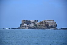
 Lawrence Rocks rocky islets in Western Victoria Lawrence Rocks rocky islets in Western Victoria | |
 | |
| Etymology | Captain Effingham Lawrence |
|---|---|
| Geography | |
| Location | Bass Strait |
| Coordinates | 38°24′30″S 141°40′10″E / 38.40833°S 141.66944°E / -38.40833; 141.66944 |
| Area | 7 ha (17 acres) |
| Length | 800 m (2600 ft) |
| Width | 50 m (160 ft) |
| Highest elevation | 90 m (300 ft) |
| Administration | |
| Australia | |
| State | Victoria |
The Lawrence Rocks are a group of two rocky islets, 6.8 ha and 1.5 ha in area, with an associated reef, 2.4 km south-east of Point Danger in western Victoria, Australia, and about 6 km south-east of the city of Portland. Geologically, the group is formed from the remnants of an extinct volcano, with the islets composed of basalt and tuff.
The islets were sighted by Lieutenant James Grant on 5 December 1800 from the survey brig HMS Lady Nelson and named for Captain Effingham Lawrence, one of the Elder Brethren of Trinity House.

Fauna

The rocks are protected as a nature reserve and are the site of a breeding colony of Australasian gannets, the overspill from which led to the establishment of a sister colony at Point Danger. The group has been identified by BirdLife International as an Important Bird Area (IBA), because it supports over 10% of the world population of Australasian gannets, being used by over 6000 birds. Other birds recorded on the rocks, and likely to breed there, include little penguins, black-faced cormorants, crested terns, silver gulls, sooty oystercatchers and small numbers of Cape gannets. The rocks are also used as a haul-out site by Australian fur seals. Seal hunting was conducted on the island in the 19th century.
Recreational dive sites
There are several named sites:
- The Nursery, at the eastern side, where there are four caves, one known as the Cockpit with a small chamber at the top, at 38° 24.280′ S, 141° 40.260′ E
- North Point, a boulder ridge off the northern end of Lawrence Rocks, at 38° 24.225′ S, 141° 40.004′ E
- The Saddle, a gully that cuts through the centre of the rocks, at 38° 24.331′ S, 141° 40.082′ E
- The Harbour, an area of gutters, ledges and swim-throughs, at 38° 24.514′ S, 141° 40.136′ E
- The wreck of the Emily S, a short distance northeast from Lawrence Rocks.
References
- ^ Grant, James (1803). The narrative of a voyage of discovery, performed in His Majesty's vessel the Lady Nelson, of sixty tons burthen: with sliding keels, in the years 1800, 1801, and 1802, to New South Wales. Printed by C. Roworth for T. Egerton. pp. 71–72. ISBN 978-0-7243-0036-5. Retrieved 25 January 2012.
- ^ Wall, Bruce (1967). "Lawrence, William Effingham (1781–1841)". Australian Dictionary of Biography. Canberra: National Centre of Biography, Australian National University. ISBN 978-0-522-84459-7. ISSN 1833-7538. OCLC 70677943. Retrieved 25 January 2012.
- ^ Pescott, T. W. (November 1980). "Seabird islands No 100, Lawrence Rocks, Victoria" (PDF). Corella. 4 (4): 107–109.
- ^ BirdLife International. (2011). Important Bird Areas factsheet: Lawrence Rocks. Downloaded from http://www.birdlife.org on 04/08/2011.
- "Point Danger Australasian Gannet Breeding Colony". Portland Holidays. Archived from the original on 19 August 2006. Retrieved 28 February 2011.
- "IBA: Lawrence Rocks". Birdata. Birds Australia. Archived from the original on 6 July 2011. Retrieved 4 August 2011.
- "Victoria: State of the Islands". 15 January 2014.
- Karen Townrow, An archaeological survey of sealing & whaling sites in Victoria, Heritage Victoria & Australian Heritage Commission, Melbourne, 1997, p.14.
- "Diving Lawrence Rocks". scubadoctor.com.au. Retrieved 21 August 2024.
| Islands and islets of Victoria, Australia | |
|---|---|
| Near East Gippsland | |
| Near Corner Inlet | |
| Near Wilsons Promontory | |
| In Western Port | |
| In Port Phillip | |
| Near Portland Bay | |
| In rivers | |
This article about a location in Victoria, Australia is a stub. You can help Misplaced Pages by expanding it. |