| Zhongbei Town 中北镇 | |
|---|---|
| Town | |
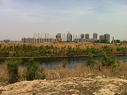
 Southern Waterway passing through Zhongbei Town, 2011 Southern Waterway passing through Zhongbei Town, 2011 | |
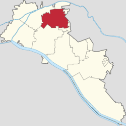
 Location in Xiqing District Location in Xiqing District | |
  | |
| Coordinates: 39°07′53″N 117°04′47″E / 39.13139°N 117.07972°E / 39.13139; 117.07972 | |
| Country | |
| Municipality | Tianjin |
| District | Xiqing |
| Village-level Divisions | 31 communities 22 villages |
| Area | |
| • Total | 38.19 km (14.75 sq mi) |
| Elevation | 7 m (23 ft) |
| Population | |
| • Total | 92,814 |
| • Density | 2,400/km (6,300/sq mi) |
| Time zone | UTC+8 (CST) |
| Postal code | 300380 |
| Area code | 022 |
Zhongbei Town (simplified Chinese: 中北镇; traditional Chinese: 中北鎮; pinyin: Zhōngběi Zhèn) is a town in Xiqing District, in the western suburbs of Tianjin, People's Republic of China. It borders Xiyingmen Subdistrict in its north, Xiangyanglu and Jialingdao Subdistricts in its east, Zhnagjiawo Town in its south, and Yangliuqing Town in its west. As of 2011, it had a total population of 92,814.
The name "Zhongbei" literally means "Middle North".
Geography
Zhongbei Town is located south of Ziya River and is bisected by the Southern Waterway (Chinese: 南运河). The National Highway 205 passes through the north of the town.
History
| Years | Status | Within |
|---|---|---|
| 1952 - 1953 | Zhong Beixie Township | Tianjin County, Tianjin |
| 1953 - 1955 | Jinxijiao District, Tianjin | |
| 1955 - 1958 | Xijiao District, Tianjin | |
| 1958 - 1961 | Nankai District, Tianjin | |
| 1961 - 1962 | Zhong Beixie People's Commune | |
| 1962 - 1963 | Xijiao District, Tianjin | |
| 1963 - 1964 | Da Shaozhikou People's Commune Zhong Beixie People's Commune Lilou People's Commune | |
| 1964 - 1968 | Da Shaozhikou People's Commune Lilou People's Commune | |
| 1968 - 1969 | Jiuyijiu People's Commune Lilou People's Commune | |
| 1969 - 1983 | Jiuyijiu People's Commune | |
| 1983 - 1984 | Jiuyijiu Township | |
| 1984 - 1992 | Zhong Beixie Township | |
| 1992 - 1997 | Xiqing District, Tianjin | |
| 1997–present | Zhongbei Town |
Administrative divisions
At the end of 2022, Zhongbei Town consists of 53 subdivisions, including 31 residential communities and 22 villages. They are listed below:
| Subdivision Names | Name Transliterations | Type |
|---|---|---|
| 溪秀苑 | Xixiu Yuan | Community |
| 侯台 | Houtai | Community |
| 东姜井 | Dong Jiangjing | Community |
| 西姜井 | Xi Jiangjing | Community |
| 大地十二城 | Dadi Shi'ercheng | Community |
| 水语花城 | Shuiyu Huacheng | Community |
| 华亭佳园 | Huating Jiayuan | Community |
| 假日风景 | Jiari Fengjing | Community |
| 富力湾 | Fuli Wan | Community |
| 大地十二城枫桦园 | Dadi Shi'ercheng Fenghua Yuan | Community |
| 福雅花园 | Fuya Huayuan | Community |
| 福悦里 | Fuyue Li | Community |
| 旭水蓝轩 | Xushui Lanxuan | Community |
| 华亭丽园 | Huating Liyuan | Community |
| 假日润园 | Jiari Runyuan | Community |
| 中信珺台 | Zhongxin Juntai | Community |
| 碧水家园 | Bishui Jiayuan | Community |
| 溪秀苑第二 | Xiwan Yuan Di'er | Community |
| 云锦世家 | Yunjin Shijia | Community |
| 红杉花苑 | Hongshan Huayuan | Community |
| 澜湾花园 | Lanwan Huayuan | Community |
| 顺通家园 | Shuntong Jiayuan | Community |
| 锦曦花苑 | Jinxi Huayuan | Community |
| 旭辉御府 | Xuhui Yufu | Community |
| 燕宇花园 | Yanyu Huayuan | Community |
| 景园里 | Jingyuan Li | Community |
| 郦景园 | Lijing Yuan | Community |
| 大安翠庭园 | Da'an Cuiting Yuan | Community |
| 甜水 | Tianshui | Community |
| 新津国际 | Xinjin Guoji | Community |
| 万汇文化广场 | Wanhui Wenhua Guangchang | Community |
| 汪庄 | Wangzhuang | Village |
| 李家园 | Li Jiayuan | Village |
| 东姜井 | Dong Jiangjing | Village |
| 西姜井 | Xi Jiangjing | Village |
| 大稍直口 | Da Shaozhikou | Village |
| 邢庄 | Xingzhuang | Village |
| 曹庄子 | Cao Zhuangzi | Village |
| 大卞庄 | Da Bianzhuang | Village |
| 东北斜 | Dong Beixie | Village |
| 中北斜 | Zhong Beixie | Village |
| 西北斜 | Xi Beixie | Village |
| 雷庄子 | Lei Zhuangzi | Village |
| 四新庄村 | Sixinzhuang Cun | Village |
| 小蒋庄 | Xiao Jiangzhuang | Village |
| 大蒋庄 | Da Jiangzhuang | Village |
| 祁庄 | Qizhuang | Village |
| 李楼 | Lilou | Village |
| 谢庄 | Xiezhuang | Village |
| 东马庄 | Dong Mazhuang | Village |
| 西马庄 | Xi Mazhuang | Village |
| 王庄 | Wangzhuang | Village |
| 大梁庄 | Da Liangzhuang | Village |
Galleries
-
 View of the Southern Waterway, 2011
-
 Interior of Tianjin Botanical Garden in the east of the town, 2011
-
 Section of Wanhua Road near the Southern Waterway, 2011
-
 Xiqing Avenue near the border with Yangliuqing, 2016
See also
External links
References
- "China: Tiānjīn Municipal Province (Districts and Townships) - Population Statistics, Charts and Map". www.citypopulation.de. Retrieved 2023-04-01.
- Zhonghua Renmin Gongheguo zheng qu da dian. Tianjin juan (Di 1 ban ed.). Beijing. 2020. ISBN 978-7-5087-6215-9. OCLC 1351675957.
{{cite book}}: CS1 maint: location missing publisher (link) - "2022年统计用区划代码和城乡划分代码" [2022 Statistical Division Codes and Urban-rural Differentiation Codes]. www.stats.gov.cn (in Chinese). Archived from the original on 2023-03-28.
| Subdivisions of Xiqing District, Tianjin | |
|---|---|
| Subdistricts | |
| Towns | |
This Tianjin location article is a stub. You can help Misplaced Pages by expanding it. |