| Wortel | |
|---|---|
| Village | |
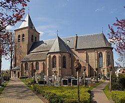
 St John the Baptist Church St John the Baptist Church | |
 | |
| Coordinates: 51°23′52″N 4°47′45″E / 51.3978°N 4.7958°E / 51.3978; 4.7958 | |
| Country | |
| Region | Flemish Region |
| Province | Antwerp |
| Municipality | Hoogstraten |
| Area | |
| • Total | 13.54 km (5.23 sq mi) |
| Population | |
| • Total | 1,844 |
| • Density | 140/km (350/sq mi) |
| Time zone | CET |
Wortel is a village in the Belgian municipality of Hoogstraten. As of 2021, it has 1,844 inhabitants.
The toponym means carrot or root in Dutch. Wortel was established in the early 19th century by the Society of Benevolence as a farming colony for the able-bodied working poor. It was meant to provide employment during a time when poverty rates were very high in the Low Countries. Along with the other colonies constructed by the Society of Benevolence, Wortel was inscribed on the UNESCO World Heritage List in 2021 as an excellent example of a unique method of housing reform and urban planning.
Gallery
References
- ^ "Bevolking per statistische sector - Sector 13014E". Statistics Belgium. Retrieved 9 May 2022.
- ^ "Colonies of Benevolence". UNESCO World Heritage Centre. United Nations Educational, Scientific, and Cultural Organization. Retrieved 14 August 2021.
External links
 Media related to Wortel at Wikimedia Commons
- (in Dutch) Official website of Hoogstraten
| Belgian municipality Hoogstraten | |
|---|---|
| Deelgemeentes | |
This Antwerp Province location article is a stub. You can help Misplaced Pages by expanding it. |


