River in New Zealand
| Waitangi River | |
|---|---|
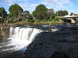
 Waitangi River flowing over Haruru Falls Waitangi River flowing over Haruru Falls | |
| Location | |
| Country | New Zealand |
| Physical characteristics | |
| Mouth | |
| • location | Bay of Islands |
| Length | 28 km (17 mi) |
The Waitangi River is a river of the Northland Region of New Zealand's North Island. It originates close to the northern shore of Lake Ōmāpere and flows eastwards to the Bay of Islands. It is considered to end either where it drops over Haruru Falls into a tidal estuary, or where the estuary opens into Te Tī Bay, just below the bridge between the historic locality of Waitangi and the town of Paihia.

See also
References
"Place name detail: Waitangi River". New Zealand Gazetteer. New Zealand Geographic Board. Retrieved 12 July 2009.
35°16′18″S 174°04′47″E / 35.2716°S 174.0797°E / -35.2716; 174.0797
This article about a river in the Northland Region is a stub. You can help Misplaced Pages by expanding it. |