| Vysoký Újezd | |
|---|---|
| Municipality | |
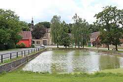
 Centre of Vysoký Újezd Centre of Vysoký Újezd | |
 Flag Flag Coat of arms Coat of arms | |
 | |
| Coordinates: 49°59′32″N 14°12′23″E / 49.99222°N 14.20639°E / 49.99222; 14.20639 | |
| Country | |
| Region | Central Bohemian |
| District | Beroun |
| First mentioned | 1310 |
| Area | |
| • Total | 11.56 km (4.46 sq mi) |
| Elevation | 423 m (1,388 ft) |
| Population | |
| • Total | 1,793 |
| • Density | 160/km (400/sq mi) |
| Time zone | UTC+1 (CET) |
| • Summer (DST) | UTC+2 (CEST) |
| Postal codes | 267 16, 267 18 |
| Website | www |
Vysoký Újezd is a municipality and village in Beroun District in the Central Bohemian Region of the Czech Republic. It has about 1,800 inhabitants.
Administrative division
Vysoký Újezd consists of three municipal parts (in brackets population according to the 2021 census):
- Vysoký Újezd (1,253)
- Kozolupy (249)
- Kuchař (190)
Kozolupy forms an exclave of the municipal territory.
Geography
Vysoký Újezd is located about 10 kilometres (6 mi) east of Beroun and 11 km (7 mi) southwest of Prague. It lies mostly in the Hořovice Uplands, only the western part of the municipality with the Kuchař village extends into the Prague Plateau. A small southwestern part the municipal territory extends into the Bohemian Karst Protected Landscape Area.
History
The first written mention of Vysoký Újezd is from 1310. The most notable owner of the estate was the Schlick family. They owned Vysoký Újezd from 1693 to 1883.
Demographics
|
|
| ||||||||||||||||||||||||||||||||||||||||||||||||||||||
| Source: Censuses | ||||||||||||||||||||||||||||||||||||||||||||||||||||||||
Transport
There are no major roads passing through the municipality. The railway that runs through the municipality is unused.
Sport
Vysoký Újezd is known for a golf course. It has an area of over 80 ha (200 acres).
Sights

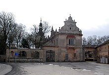
The main landmark is the Vysoký Újezd Castle. It was built in the Neo-Renaissance style in 1897 as an extension of a Baroque manor house. Today it is dilapidated and unused.
References
- "Population of Municipalities – 1 January 2024". Czech Statistical Office. 2024-05-17.
- "Public Census 2021 – basic data". Public Database (in Czech). Czech Statistical Office. 2022.
- "Obec" (in Czech). Obec Vysoký Újezd. Retrieved 2024-05-22.
- "Historický lexikon obcí České republiky 1869–2011" (in Czech). Czech Statistical Office. 2015-12-21.
- "Population Census 2021: Population by sex". Public Database. Czech Statistical Office. 2021-03-27.
- "Albatross Golf Resort – 18jamkové hřiště nejvyššího evropského standardu" (in Czech). CzechTourism. Retrieved 2024-05-22.
- "Zámek" (in Czech). National Heritage Institute. Retrieved 2024-05-22.