| This article relies largely or entirely on a single source. Relevant discussion may be found on the talk page. Please help improve this article by introducing citations to additional sources. Find sources: "Varėnė" – news · newspapers · books · scholar · JSTOR (July 2013) |
| Varėnė | |
|---|---|
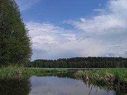
 Varėnė near Lake Varėnis Varėnė near Lake Varėnis | |
| Location | |
| Country | Lithuania |
| Physical characteristics | |
| Source | |
| • location | Alytus district municipality, Alytus County |
| Mouth | Merkys |
| • coordinates | 54°14′46″N 24°33′13″E / 54.2460°N 24.5536°E / 54.2460; 24.5536 |
| Length | 48 km (30 mi) |
| Basin size | 411 km (159 sq mi) |
| Discharge | |
| • average | 3.36 m/s (119 cu ft/s) |
| Basin features | |
| Progression | Merkys→ Neman→ Baltic Sea |
| Tributaries | |
| • left | Žiegždupis, Žižma, Dusmena, Musė |
| • right | Juodupė, Niedulė, Svetus, Abista |
The Varėnė is a river of Alytus district municipality and Varėna district municipality, Alytus County, southern Lithuania. It flows for 48 kilometres and has a basin area of 411 km².
The Varėnė begins near Skaičionys village. There are a lot of water springs along its upper course. Varėnė crosses the Varėnis Lake near its mouth. It joins the Merkys near Varėna city.
Varėnė suits well for water tourism.
References
- LIETUVOS RESPUBLIKOS UPIŲ IR TVENKINIŲ KLASIFIKATORIUS (Republic of Lithuania- River and Pond Classifications). Ministry of Environment (Lithuania). Accessed 2011-11-11.
This article related to a river in Lithuania is a stub. You can help Misplaced Pages by expanding it. |