Unincorporated community in Indiana, United States
| Vandalia, Indiana | |
|---|---|
| Unincorporated community | |
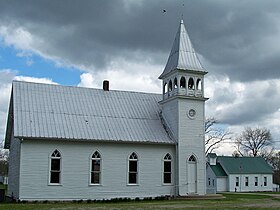
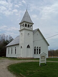
 Vandalia, Indiana Historic Chapel & School Vandalia, Indiana Historic Chapel & School | |
  | |
| Coordinates: 39°18′45″N 86°51′58″W / 39.31250°N 86.86611°W / 39.31250; -86.86611 | |
| Country | United States |
| State | Indiana |
| County | Owen |
| Township | Lafayette |
| Elevation | 787 ft (240 m) |
| Time zone | UTC-5 (Eastern (EST)) |
| • Summer (DST) | UTC-4 (EDT) |
| ZIP code | 47868 |
| Area code(s) | 812, 930 |
| GNIS feature ID | 445224 |
Vandalia is an unincorporated community in Lafayette Township, Owen County, in the U.S. state of Indiana.
History
Vandalia was laid out in 1839. A post office was established at Vandalia in 1846, and remained in operation until it was discontinued in 1927. Two remaining landmarks and reminders of Vandalia's past are the historic chapel (built in 1895) and one-room schoolhouse (building completed in 1868), preserved and maintained by the Vandalia Community Preservation Association.


Geography
Vandalia is located at 39°18′45″N 86°51′58″W / 39.31250°N 86.86611°W / 39.31250; -86.86611 at an elevation of 787 feet. It lies at the east end of State Road 246 where it intersects State Road 46. The main village originated near coordinates 39.3137257,-86.8679851.
References
- "US Board on Geographic Names". United States Geological Survey. October 25, 2007. Retrieved May 1, 2017.
- "Vandalia, Indiana". Geographic Names Information System. United States Geological Survey. Retrieved July 19, 2017.
- Blanchard, Charles (1884). Counties of Clay and Owen, Indiana: Historical and Biographical. F.A. Battey & Company. pp. 820.
- "Owen County". Jim Forte Postal History. Retrieved September 21, 2015.
- "Vandalia Community Preservation Association". Organization Founded 1995.
- "Google Maps". Location where the main village of Vandalia, Indiana originated.
External links
| Municipalities and communities of Owen County, Indiana, United States | ||
|---|---|---|
| County seat: Spencer | ||
| Towns | ||
| Townships | ||
| CDPs | ||
| Other communities | ||
| Ghost town | ||
| Footnotes | ‡This populated place also has portions in an adjacent county or counties | |
This Owen County, Indiana location article is a stub. You can help Misplaced Pages by expanding it. |
