| This article needs additional citations for verification. Please help improve this article by adding citations to reliable sources. Unsourced material may be challenged and removed. Find sources: "Brock, Ontario" – news · newspapers · books · scholar · JSTOR (January 2018) (Learn how and when to remove this message) |
| Brock | |
|---|---|
| Township (lower-tier) | |
| Township of Brock | |
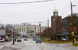
 Beaverton Beaverton | |
 Coat of arms Coat of arms | |
  | |
| Coordinates: 44°19′N 79°05′W / 44.317°N 79.083°W / 44.317; -79.083 | |
| Country | Canada |
| Province | Ontario |
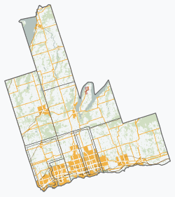
| Region | Durham |
| Incorporated | 1974 |
| Government | |
| • Mayor | Walter Schummer |
| • Councillors |
List
|
| Area | |
| • Total | 423.73 km (163.60 sq mi) |
| Population | |
| • Total | 11,642 |
| • Density | 27/km (71/sq mi) |
| Website | www.townshipofbrock.ca |
Brock is a township in the Regional Municipality of Durham, Ontario, Canada. Brock Township is also a former municipality and geographic township prior to the amalgamation that formed the current municipality.
The Trent–Severn Waterway forms part of the northern border of the municipality, which enters Lake Simcoe through Ramara Township. There are five locks in Brock. Thorah Island in Lake Simcoe is within the municipal boundaries of Brock.
History
The original Brock Township was surveyed in 1817 as part of York County and the first meetings were held in 1833. The township was named for Major General Sir Isaac Brock (1769–1812) whose estate received free land here for his service in the War of 1812. William Bagshaw became Brock's first Postmaster and Justice of the Peace in 1819 when he owned property on Concession 9. Other early, settler ancestors included names like: Acton, Charters, Dusto, Purvis, Rundle, Bagshaw, Doble, Phair, St. John, Umphrey, Brethour, Doyle, Fallowdown, Ruddy and Vrooman (for whom the semi-ghost town of Vroomanton was named).
In 1852, the Township became part of the newly created Ontario County. In 1878, Cannington was incorporated as a village and was no longer part of the Township for municipal purposes.
In 1974, Brock was amalgamated with Thorah Township and the villages of Beaverton and Cannington to form the new Township of Brock.
Communities
Beaverton is the largest community and commercial centre of the township, while Cannington is home to the municipal administration and local high school.
Beaverton is the commercial and financial centre for the township, and several stores, services and entertainment facilities are located there. Several chain outlets such as McDonald's, Independent Grocer and Tim Hortons are located along Highway 12.
Smaller communities in the township include Ball Subdivision, Blackwater, Cedar Beach, Creightons Corners, Derryville, Gamebridge, Layton, Maple Beach, Port Bolster, Pinedale, Saginaw, Sunderland, Thorah Beach, Vallentyne, Vroomanton, Wick and Wilfrid.
Local Government
Interactive map of Brock electoral wardsBrock is governed by a mayor, a Regional Councillor and five Councillors, each representing one of the five municipal wards. As of the 2022 election, the elected council members are:
- Mayor: Walter Schummer
- Councillors:
- Ward 1: Peter Frank
- Ward 2: Claire Doble
- Ward 3: Angela Canavan
- Ward 4: Cria Pettingill
- Ward 5: Lynn Campbell
The township faced controversy following the 2010 municipal election, in which then-incumbent mayor Larry O'Connor was reelected by a margin of just 13 votes over Terry Clayton. The narrow margin resulted in a judicial recount battle, and O'Connor resigned as mayor on March 28, 2011. The municipal council subsequently appointed Clayton as mayor.
Demographics
In the 2021 Census of Population conducted by Statistics Canada, Brock had a population of 12,567 living in 4,788 of its 5,297 total private dwellings, a change of 7.9% from its 2016 population of 11,642. With a land area of 422.64 km (163.18 sq mi), it had a population density of 29.7/km (77.0/sq mi) in 2021.
According to the 2016 Census, 94% of Brock residents have English as their mother tongue (one of the highest percentages in the Greater Toronto Area). No other mother tongue reaches 1%. The residents of Brock are older with a median age of 46.5 compared to the provincial average of 41.3.
| Year | Pop. | ±% |
|---|---|---|
| 1991 | 11,057 | — |
| 1996 | 11,705 | +5.9% |
| 2001 | 12,110 | +3.5% |
| 2006 | 11,979 | −1.1% |
| 2011 | 11,341 | −5.3% |
| 2016 | 11,642 | +2.7% |
Notable people
- George Arthur Welsh – decorated World War I and World War II flying ace hero
- Duncan Macpherson – editorial cartoonist
- Basil McRae – former NHL player
- Hugh Livingstone Macneil – southern California pioneer, born in Wick
See also
References
- "John Grant is officially the new mayor of Brock Township". thestar.com. 2021-03-18. Retrieved 2021-04-01.
- "Mayor Larry O'Connor resigns". mykawartha.com, March 29, 2011.
- "Clayton appointed mayor". mykawartha.com, May 2, 2011.
- "Population and dwelling counts: Canada, provinces and territories, census divisions and census subdivisions (municipalities), Ontario". Statistics Canada. February 9, 2022. Retrieved April 2, 2022.
- "Census Profile, 2016 Census Brock, Township". Statistics Canada. 8 February 2017. Retrieved November 24, 2018.
External links
| Places adjacent to Brock, Ontario | ||||||||||||||||
|---|---|---|---|---|---|---|---|---|---|---|---|---|---|---|---|---|
| ||||||||||||||||
| Municipalities of Durham Region, Ontario | |
|---|---|
| Greater Toronto Area | ||
|---|---|---|
| Largest city: Toronto | ||
| Regions |  | |
| Cities | ||
| Towns | ||
| Townships | ||
| Municipalities | ||