| Ubinas | |
|---|---|
| District | |
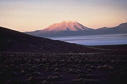
 Ubinas volcano in the Ubinas District Ubinas volcano in the Ubinas District | |
| Country | |
| Region | Moquegua |
| Province | General Sánchez Cerro |
| Capital | Ubinas |
| Government | |
| • Mayor | Angel Americo Quispitupac Soto |
| Area | |
| • Total | 874.57 km (337.67 sq mi) |
| Elevation | 3,376 m (11,076 ft) |
| Population | |
| • Total | 4,804 |
| • Density | 5.5/km (14/sq mi) |
| Time zone | UTC-5 (PET) |
| UBIGEO | 180210 |
Ubinas District is one of eleven districts of the province General Sánchez Cerro in the Moquegua Region in Peru.
Geography
The highest elevation in the district is the Ubinas volcano. Other mountains are listed below:
- Aqu Q'asa
- Chhuqu
- Hatun Urqu
- Llallawani
- Llallawi
- Llaqtayuq
- Minasniyuq
- Paru Sarayuq
- Parwayuni
- Pilluni
- Pirwani
- Puka Salla
- Pukara
- Puntayuq
- P'aqu Urqu
- Qaqawara
- Qayqu Punta
- Qucha Q'asa
- Qhuyu Parwayuni
- Q'ara Muqu
- Q'illu Q'asa
- Q'irayuq
- Sura Wañusqa
- Suri Wasi
- Ubinas
- Wit'u Pata
- Wit'uni
- Yana Qaqa
- Yuraq Kancha
- Yuraq Muqu
- Yuraq Urqu
Climate
| Climate data for Ubinas, elevation 3,381 m (11,093 ft), (1991–2020) | |||||||||||||
|---|---|---|---|---|---|---|---|---|---|---|---|---|---|
| Month | Jan | Feb | Mar | Apr | May | Jun | Jul | Aug | Sep | Oct | Nov | Dec | Year |
| Mean daily maximum °C (°F) | 18.3 (64.9) |
17.7 (63.9) |
18.3 (64.9) |
19.1 (66.4) |
18.6 (65.5) |
18.1 (64.6) |
17.8 (64.0) |
18.8 (65.8) |
19.4 (66.9) |
20.0 (68.0) |
20.2 (68.4) |
19.7 (67.5) |
18.8 (65.9) |
| Mean daily minimum °C (°F) | 6.4 (43.5) |
6.5 (43.7) |
6.2 (43.2) |
4.9 (40.8) |
2.6 (36.7) |
1.4 (34.5) |
1.3 (34.3) |
2.2 (36.0) |
3.5 (38.3) |
4.4 (39.9) |
4.5 (40.1) |
5.7 (42.3) |
4.1 (39.4) |
| Average precipitation mm (inches) | 93.5 (3.68) |
100.2 (3.94) |
57.6 (2.27) |
17.4 (0.69) |
2.6 (0.10) |
2.0 (0.08) |
3.2 (0.13) |
2.8 (0.11) |
2.9 (0.11) |
4.2 (0.17) |
5.3 (0.21) |
33.2 (1.31) |
324.9 (12.8) |
| Source: National Meteorology and Hydrology Service of Peru | |||||||||||||
References
- (in Spanish) Instituto Nacional de Estadística e Informática. Banco de Información Distrital Archived 2008-04-23 at the Wayback Machine. Retrieved April 11, 2008.
- escale.minedu.gob.pe - UGEL map of the General Sánchez Cerro Province (Moquegua Region)
- escale.minedu.gob.pe - UGEL map of the Mariscal Nieto Province (Moquegua Region)
- "Normales Climaticás Estándares y Medias 1991-2020". National Meteorology and Hydrology Service of Peru. Archived from the original on 21 August 2023. Retrieved 6 November 2023.
| |
|---|---|
| General Sánchez Cerro | |
| Ilo | |
| Mariscal Nieto | |
This Moquegua Region geography article is a stub. You can help Misplaced Pages by expanding it. |
16°23′12″S 70°51′21″W / 16.3867°S 70.8559°W / -16.3867; -70.8559
Categories: