| Tipton Airport | |||||||||||
|---|---|---|---|---|---|---|---|---|---|---|---|
 | |||||||||||
| Summary | |||||||||||
| Airport type | Public | ||||||||||
| Owner | Tipton Airport Authority | ||||||||||
| Location | Fort Meade / Odenton, Maryland | ||||||||||
| Elevation AMSL | 150 ft / 46 m | ||||||||||
| Coordinates | 39°05′07″N 076°45′34″W / 39.08528°N 76.75944°W / 39.08528; -76.75944 | ||||||||||
| Website | TiptonAirport.org | ||||||||||
| Map | |||||||||||
  | |||||||||||
| Runways | |||||||||||
| |||||||||||
| Statistics (2023) | |||||||||||
| |||||||||||
| Source: Federal Aviation Administration | |||||||||||
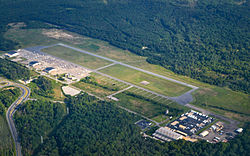
Tipton Airport (IATA: FME, ICAO: KFME, FAA LID: FME) is a public airport just south of Fort George G. Meade in Odenton, Anne Arundel County, Maryland. The facility is bordered by Fort Meade, the National Security Agency, and the Patuxent Wildlife Research Center. The airport opened in 1999 on the site of a former United States Army Airfield that was closed in 1995. It is operated by the Tipton Airport Authority.
Facilities and aircraft
Tipton Airport covers an area of 366 acres (148 ha) and contains one paved runway (10/28) measuring 3,000 ft × 75 ft (914 m × 23 m).
For The 12-month period ending March 24, 2023, the airport had 38,124 aircraft operations, an average of 104 per day: 100% general aviation, <1% air taxi, and <1% military. There are 97 aircraft/rotorcraft based at the airport: 76 single-engine, 7 multi-engine and 14 helicopters.
History
Tipton Airport was originally a military airfield. It was constructed in 1960 over a landfill on the outskirts of Fort Meade and was named Fort George G. Meade Army Airfield. The new airfield replaced a smaller airstrip that had been operating since at least 1935 at a site approximately two miles northeast of Tipton's location (what is now the Fort Meade post exchange and commissary complex). In April 1962, the field was renamed Tipton Army Airfield in honor of Colonel William Tipton, a Maryland National Guard officer and decorated veteran of both world wars. Tipton was killed in an aircraft crash in Ohio at the end of World War II.
At 2 A.M. on February 17, 1974, Robert K. Preston stole a Huey helicopter from Tipton Field, flew it to Washington, D.C., and hovered for six minutes over the White House before descending on the South Lawn, about 100 yards (91 m) from the West Wing.
Public Law 100–526, the Base Alignment and Closure (BRAC) Act of 1988, designated Tipton Army Airfield for closure, and as a result the land on which Tipton is located was transferred to civilian control in 1995. Following a lengthy environmental remediation, which included the removal of unexploded ordnance and hazardous waste, it was opened to civilian traffic. A formal dedication of Tipton Airport was held on October 27, 1999, and on November 1, 1999, the airport held a grand opening.
See also
References
- ^ FAA Airport Form 5010 for FME PDF, retrieved 2023-08-18
- Tipton Airport (official site)
- (Original) Fort Meade Auxiliary Army Airfield Archived 2011-10-12 at the Wayback Machine, retrieved 2011-01-14
- Minami, Wayde. Tipton Had Distinguished Career in War and Peace, retrieved 2011-01-14
- Freeze, Christopher. "The Time a Stolen Helicopter Landed on the White House Lawn - Robert Preston's wild ride". Air & Space. Smithsonian. Retrieved 22 March 2017.
- Tipton Airport Homepage, retrieved 2011-01-14
- Davis, Clayton. A History of Tipton Army Airfield Archived 2012-07-09 at archive.today, retrieved 2011-01-14
External links
- Resources for this airport:
- FAA airport information for FME
- AirNav airport information for KFME
- ASN accident history for FME
- FlightAware airport information and live flight tracker
- NOAA/NWS weather observations: current, past three days
- SkyVector aeronautical chart, Terminal Procedures