| Tel Kaif Classical Syriac: ܬܠ ܟܐܦܐ, Arabic: تل كيف | |
|---|---|
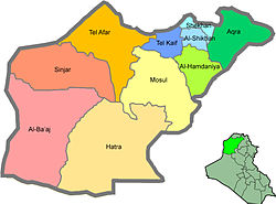
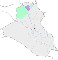
 Tel Keppe District (blue) in Ninawa Tel Keppe District (blue) in Ninawa | |
| Country | Iraq |
| Governorate | Nineveh |
| Seat | Tel Keppe |
| Area | |
| • Total | 1,244 km (480 sq mi) |
| Population | |
| • Total | 167,647 |
| Time zone | UTC+3 (AST) |
Tel Keppe District (also Tel Keif, Tall Kayf, Tel Kayf or Tel Kef (Classical Syriac: ܬܠ ܟܐܦܐ), (Arabic: تل كيف)), Aramaic for "Hill of Stones", is a district in Nineveh Governorate, Iraq. It is majority Arab Muslim with a minority of Assyrians.
Towns and villages include:
- Tel Keppe
- Alqosh
- Khatarah
- Tesqopa
- Batnaya
- Sharafiya
- Baqofah
- Bozan
- Beban
- Babirah
- Dughata
- Sreshka
- Khoshaba
See also
| Nineveh Plains in Nineveh Governorate, northern Iraq | |||||||||||
|---|---|---|---|---|---|---|---|---|---|---|---|
| Main settlements |
|  | |||||||||
| Religious sites |
| ||||||||||
| Archaeological sites | |||||||||||
| See also | |||||||||||
This Iraq geographical location article is a stub. You can help Misplaced Pages by expanding it. |
