Unincorporated community in Pennsylvania, United States
| Tarrs | |
|---|---|
| Unincorporated community | |
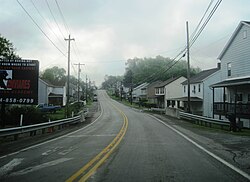
 PA 31 eastbound in Tarrs PA 31 eastbound in Tarrs | |
  | |
| Coordinates: 40°10′12″N 79°35′53″W / 40.17000°N 79.59806°W / 40.17000; -79.59806 | |
| Country | United States |
| State | Pennsylvania |
| County | Westmoreland |
| Elevation | 1,158 ft (353 m) |
| Time zone | UTC-5 (Eastern (EST)) |
| • Summer (DST) | UTC-4 (EDT) |
| ZIP codes | 15688 |
| GNIS feature ID | 1189287 |
Tarrs is an unincorporated community and coal town that is located in East Huntingdon Township, Westmoreland County, Pennsylvania, United States.
Situated on Pennsylvania Route 31 approximately three miles (4.8 km) west of Mt. Pleasant, it is the only location in Pennsylvania known to have an active and running ACA Allertor 125 Civil Defense warning siren.
History

Tarrs has its own post office, with zip code 15688. It was established in April 1828.
The town was the site of a coal mine, first developed in 1873 by D. A. Dillinger and Brothers. It was later acquired by the Southwest Coal and Coke Company and was known as the "No. 3" mine. Approximately 250 coke ovens were eventually located there.
In 1906, historian John Newton Boucher described Tarrs as being located along "the South-West Branch of the Pennsylvania Railroad" between Ruffs Dale and Alverton. Boucher also mentioned a location in Westmoreland County known as Tarr Station, presumably related to the railroad.
By 1910, the population had reached roughly five hundred. The mine and coke works closed in 1923.
References
- U.S. Geological Survey Geographic Names Information System: Tarrs, Pennsylvania
- "Tarrs - Post Office". U.S. Postal Service.
- http://webpmt.usps.gov/pmt007.cfm
- "Postmaster Finder". USPS - Display Post Offices by County. United States Postal Service. Retrieved June 27, 2022.
- Muller, Edward K. and Carlisle, Ronald C. (1994). "WESTMORELAND COUNTY, PENNSYLVANIA: An Inventory of Historic Engineering and Industrial Sites". National Park Service, U.S. Department of the Interior. pp. 157–158.
{{cite web}}: CS1 maint: multiple names: authors list (link) - Boucher, John Newton (1906). History of Westmoreland County, Pennsylvania. Lewis Publishing Company. pp. 283, 390. Retrieved June 25, 2022.
See also
ACA Allertor 125 warning/Civil Defense siren video on Wikimedia Commons.
| Greater Pittsburgh | ||||||||||
|---|---|---|---|---|---|---|---|---|---|---|
| Pittsburgh–New Castle–Weirton combined statistical area | ||||||||||
| Counties |
|  | ||||||||
| Major cities | ||||||||||
| Cities and towns 15k–50k (in 2010) | ||||||||||
| Airports | ||||||||||
| Topics | ||||||||||
