| Sildpollneset | |
|---|---|
| Peninsula | |
 | |
| Interactive map of the peninsula | |
| Coordinates: 68°19′20″N 14°43′02″E / 68.32222°N 14.71722°E / 68.32222; 14.71722 | |
| Location | Lofoten, Norway |
| Part of | Austvågøya |
| Offshore water bodies | Austnesfjorden |
| Elevation | 5 m (16 ft) |
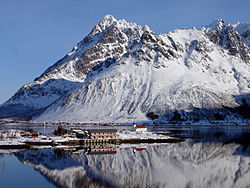
Sildpollneset is a peninsula in the Austnesfjorden on the island of Austvågøya in the Lofoten archipelago. It is located in Vågan Municipality in Nordland county, Norway. It is located just east of the European route E10 highway. Sildpollnes Church is located at the end of the peninsula.
References
- "Sildpollneset" (in Norwegian). yr.no. Retrieved 2012-07-20.
- "Informasjon om stadnamn". Norgeskart (in Norwegian). Kartverket. Retrieved 2024-08-11.
This Nordland location article is a stub. You can help Misplaced Pages by expanding it. |