| This article needs additional citations for verification. Please help improve this article by adding citations to reliable sources. Unsourced material may be challenged and removed. Find sources: "Schoonoord, Coevorden" – news · newspapers · books · scholar · JSTOR (April 2022) (Learn how and when to remove this message) |
| Schoonoord | |
|---|---|
| Village | |
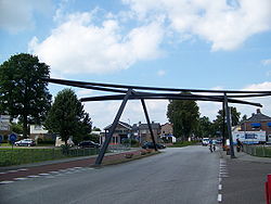
 A bridge in the centre of the village A bridge in the centre of the village | |
  | |
| Coordinates: 52°50′46″N 6°45′22″E / 52.84611°N 6.75611°E / 52.84611; 6.75611 | |
| Country | Netherlands |
| Province | Drenthe |
| Municipality | Coevorden |
| Area | |
| • Total | 12.03 km (4.64 sq mi) |
| Elevation | 19 m (62 ft) |
| Population | |
| • Total | 2,130 |
| • Density | 180/km (460/sq mi) |
| Time zone | UTC+1 (CET) |
| • Summer (DST) | UTC+2 (CEST) |
| Postal code | 7848 |
| Dialing code | 0591 |
Schoonoord is a village in the Netherlands and it is part of the Coevorden municipality in Drenthe. It has an altitude of about 20 meters (65 feet). The population was 2,219 with 970 households in 2004.
History
Schoonoord was founded in 1854 by labourmen from Smilde who dug the Oranjekanaal. Later, when the peat in the neighbouring Odoornerveen was being cut, more workers settled in the village. The name of the village was thought up by the peat digger Klijn. It literally means "beautiful place".
Places of interest
Due to the 100th anniversary of the village a few turf huts were built. This collection has evolved to the open-air museum Ellert en Brammert. Also, there is a megalith called the Papeloze Kerk nearby Schoonoord. A windmill in Schoonoord has been converted to residential accommodation but is missing its cap and sails.
References
- ^ "Kerncijfers wijken en buurten 2021". Central Bureau of Statistics. Retrieved 10 April 2022.
two entries
- "Postcodetool for 7848AA". Actueel Hoogtebestand Nederland (in Dutch). Het Waterschapshuis. Retrieved 10 April 2022.
External links
 Media related to Schoonoord at Wikimedia Commons
52°51′N 6°45′E / 52.850°N 6.750°E / 52.850; 6.750
| Populated places in the municipality of Coevorden | |
|---|---|
| Towns | |
| Villages | |
| Hamlets | |
| List of cities, towns and villages in Drenthe | |
This Drenthe location article is a stub. You can help Misplaced Pages by expanding it. |