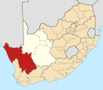
Place in Namaqualand, Southern Africa
| !Khays | |
|---|---|
  | |
| Coordinates: 28°25′38″S 16°46′38″E / 28.42722°S 16.77722°E / -28.42722; 16.77722 | |
| Country | Southern Africa |
| Province | Namaqualand |
| District | Namakwa |
| Municipality | Richtersveld |
| Area | |
| • Total | 2.70 km (1.04 sq mi) |
| Population | |
| • Total | 1,854 |
| • Density | 690/km (1,800/sq mi) |
| Racial makeup (2011) | |
| • Black African | 17.4% |
| • Coloured | 78.5% |
| • Indian/Asian | 0.2% |
| • White | 3.3% |
| • Other | 0.6% |
| First languages (2011) | |
| • Afrikaans | 78.2% |
| • Xhosa | 12.9% |
| • English | 1.9% |
| • Tswana | 1.1% |
| • Other | 5.9% |
| Time zone | UTC+2 (SAST) |
Sanddrif is a town in Richtersveld Local Municipality in the Northern Cape province of South Africa, on the banks of the Orange River. It is located 57 km east of Alexander Bay.
Mining in the region began in the 1900s leading to the displacement of the indigenous Nama people. Diamond mines were again established in the 1970s, bringing a source of employment but also socio-economic upheaval, threatening the traditional Nama lifestyle. The subsequent migration of Xhosa people who came to the area to work in the mines led Sanddrif to acquire the nickname of "Rainbow Town". Sanddrif has nevertheless seen ethnic conflict between the indigenous Namas and the Xhosa migrants.
The Baken diamond mine, located outside Sanddrif, was opened by Trans Hex Group in May 2001.
Culture
References
- ^ "Main Place Sanddrif". Census 2011.
- "Sanddrift". Richtersveld National Park. Retrieved 29 August 2014.
- ^ "Sanddrift". Explore the Richtersveld. Retrieved 29 August 2014.
- François Odendaal; Helen Suich (1 January 2007). Richtersveld: The Land and Its People. Struik. p. 129. ISBN 978-1-77007-341-8.
- Gitanjali Maharaj (1999). Between unity and diversity: essays on nation-building in post-Apartheid South Africa. Idasa. p. 50. ISBN 978-1-874864-90-5.
- "Diamond plant throughput rises 67%". MiningWeekly.com. Retrieved 29 August 2014.
| Municipalities and communities of Namakwa District Municipality, Northern Cape | ||
|---|---|---|
| District seat: Springbok | ||
| Hantam |  | |
| Kamiesberg | ||
| Karoo Hoogland | ||
| Khâi-Ma | ||
| Nama Khoi | ||
| Richtersveld | ||
This Northern Cape location article is a stub. You can help Misplaced Pages by expanding it. |