| Rosenbach | |
|---|---|
| Municipality | |
 Coat of arms Coat of arms | |
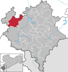
Location of Rosenbach within Vogtlandkreis district
 | |
  | |
| Coordinates: 50°32′N 12°2′E / 50.533°N 12.033°E / 50.533; 12.033 | |
| Country | Germany |
| State | Saxony |
| District | Vogtlandkreis |
| Area | |
| • Total | 67.34 km (26.00 sq mi) |
| Elevation | 487 m (1,598 ft) |
| Population | |
| • Total | 4,027 |
| • Density | 60/km (150/sq mi) |
| Time zone | UTC+01:00 (CET) |
| • Summer (DST) | UTC+02:00 (CEST) |
| Postal codes | 08539 |
| Dialling codes | 037431 |
| Vehicle registration | V, AE, OVL, PL, RC |
Rosenbach (official name: Rosenbach/Vogtl.) is a municipality in the Vogtlandkreis district, in Saxony, Germany. It was formed on 1 January 2011 by the merger of the former municipalities Leubnitz, Mehltheuer and Syrau.
References
- "Einwohnerzahlen nach Gemeinden als Excel-Arbeitsmappe" (XLS) (in German). Statistisches Landesamt des Freistaates Sachsen. 2024.
- Gebietsänderungen vom 01. Januar bis 31. Dezember 2011, Statistisches Bundesamt
This Vogtlandkreis location article is a stub. You can help Misplaced Pages by expanding it. |