| Romita | |
|---|---|
| City and municipality | |
| Municipal of Romita | |
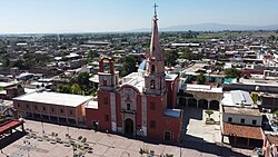
 View of Romita Largest Parish's View of Romita Largest Parish's | |
 Coat of arms Coat of arms | |
| Location of Romita within Guanajuato | |
  | |
| Coordinates: 20°52′15″N 101°31′01″W / 20.87083°N 101.51694°W / 20.87083; -101.51694 | |
| Country | |
| State | |
| Region | West Centro |
| Municipality | Romita |
| Foundation | May 16, 1885 |
| Founded by |
|
| Government | |
| • Municipal President | |
| Population | |
| • City and municipality | 65,766 |
| • Urban | 65,766 |
| Time zone | UTC−6 (CST) |
| • Summer (DST) | UTC-5 (CDT) |
| Website | www |
Romita is a Mexican city (and municipality) located in the Southwest region of the state of Guanajuato. The municipality has an area of 442.10 square kilometres (1.46% of the surface of the state) and is bordered to the north by León, to the east by Silao, to the southwest by Abasolo and Cuerámaro, and to the west by Manuel Doblado and San Francisco del Rincón. The municipality had a population of 105,825 inhabitants according to the 2005 census.
The municipal president of Romita is Pedro Kiyoshi Tanamachi Reyes.
External links
- Romita official website (content in Spanish)
References
- "2005 Census". INEGI: Instituto Nacional de Estadística, Geografía e Informática. Archived from the original on 2013-04-06. Retrieved 2007-09-14.
- "State of Guanajuato". Mexican Municipality Encyclopedia - Enciclopedia de los Municipios de México. Archived from the original on 2007-09-30. Retrieved 2007-09-14.
- Staff, PREPGTO (2024-06-02). "Programa de Resultados Electorales Preliminares 2024 Elecciones Estatales de Guanajuato (Romita)" (in Spanish). Retrieved 2023-12-14.
This article about a location in the Mexican state of Guanajuato is a stub. You can help Misplaced Pages by expanding it. |
