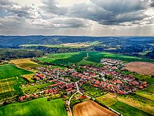
| Rokycany District Okres Rokycany | |
|---|---|
| District | |
 Location in the Plzeň Region within the Czech Republic Location in the Plzeň Region within the Czech Republic | |
 | |
| Coordinates: 49°48′N 13°41′E / 49.800°N 13.683°E / 49.800; 13.683 | |
| Country | |
| Region | Plzeň |
| Capital | Rokycany |
| Area | |
| • Total | 656.62 km (253.52 sq mi) |
| Population | |
| • Total | 50,804 |
| • Density | 77/km (200/sq mi) |
| Time zone | UTC+1 (CET) |
| • Summer (DST) | UTC+2 (CEST) |
| Municipalities | 68 |
| * Towns | 6 |
| * Market towns | 2 |
Rokycany District (Czech: okres Rokycany) is a district in the Plzeň Region of the Czech Republic. Its capital is the town of Rokycany.
Administrative division
Rokycany District is formed by only one administrative district of municipality with extended competence: Rokycany.
List of municipalities
Towns are marked in bold and market towns in italics:
Bezděkov - Břasy - Březina - Bujesily - Bušovice - Cekov - Cheznovice - Chlum - Chomle - Čilá - Dobřív - Drahoňův Újezd - Ejpovice - Hlohovice - Holoubkov - Hrádek - Hradiště - Hůrky - Kakejcov - Kamenec - Kamenný Újezd - Kařez - Kařízek - Klabava - Kladruby - Kornatice - Lhota pod Radčem - Lhotka u Radnic - Liblín - Líšná - Litohlavy - Medový Újezd - Mešno - Mirošov - Mlečice - Mýto - Němčovice - Nevid - Osek - Ostrovec-Lhotka - Plískov - Podmokly - Příkosice - Přívětice - Radnice - Raková - Rokycany - Sebečice - Sirá - Skomelno - Skořice - Smědčice - Štítov - Strašice - Svojkovice - Těně - Terešov - Těškov - Trokavec - Týček - Újezd u Svatého Kříže - Vejvanov - Veselá - Vísky - Volduchy - Všenice - Zbiroh - Zvíkovec
Geography

The terrain is hilly, most of the territory has the character of highlands. The territory extends into five geomorphological mesoregions: Křivoklát Highlands (centre and northeast), Plasy Uplands (northwest), Švihov Highlands (southwest), Brdy Highlands (southeast) and Hořovice Uplands (small part in the east). The highest point of the district is the western peak of the mountain Koruna in Těně with an elevation of 832 m (2,730 ft), the lowest point is the river bed of the Berounka in Čilá at 255 m (837 ft).
From the total district area of 656.6 km (253.5 sq mi), agricultural land occupies 266.0 km (102.7 sq mi), forests occupy 321.0 km (123.9 sq mi), and water area occupies 10.3 km (4.0 sq mi). Forests cover 48.9% of the district's area.
The Berounka forms large part of the district border in west and north. There are no significant rivers inside the district. The longest river is the Klabava, a tributary of the Berounka. The largest body of water is the fishpond Hořejší padrťský rybník with an area of 78.8 ha (195 acres).
There are two protected landscape areas: Brdy and Křivoklátsko.
Demographics
As of 2024, Rokycany District is the second least populated district in the country.
|
|
| ||||||||||||||||||||||||||||||||||||||||||||||||||||||
| Source: Censuses | ||||||||||||||||||||||||||||||||||||||||||||||||||||||||
Most populated municipalities
| Name | Population | Area (km) |
|---|---|---|
| Rokycany | 14,386 | 31 |
| Strašice | 2,917 | 35 |
| Hrádek | 2,801 | 6 |
| Zbiroh | 2,527 | 32 |
| Břasy | 2,300 | 21 |
| Mirošov | 2,245 | 14 |
| Radnice | 1,857 | 11 |
| Mýto | 1,594 | 18 |
| Holoubkov | 1,447 | 4 |
| Osek | 1,417 | 18 |
Economy
The largest employers with headquarters in Rokycany District and at least 500 employees are:
| Economic entity | Location | Number of employees | Main activity |
|---|---|---|---|
| Geis CZ | Ejpovice | 500–999 | Transportation support activities |
| Hutchinson | Rokycany | 500–999 | Manufacture of rubber products |
| Duvenbeck Logistik | Volduchy | 500–999 | Freight transport by road |
Transport
The D5 motorway (part of the European route E50) from Prague to Plzeň and the Czech-German border passes through the district.
Sights

The most important monument in the district and the only one protected as a national cultural monument is the Hammer Mill at Dobřív.
The best-preserved settlements, protected as monument reservations and monument zones, are:
The most visited tourist destination is the Zbiroh Castle in Zbiroh.
Notable people
Main category: People from Rokycany DistrictReferences
- ^ "Land use (as at 31 December)". Public database. Czech Statistical Office. Retrieved 2025-01-16.
- ^ "Population of Municipalities – 1 January 2024". Czech Statistical Office. 2024-05-17.
- "Padrťské rybníky". Poznej Brdy (in Czech). Retrieved 2023-02-18.
- "Historický lexikon obcí České republiky 1869–2011" (in Czech). Czech Statistical Office. 2015-12-21.
- "Population Census 2021: Population by sex". Public Database. Czech Statistical Office. 2021-03-27.
- "Registr ekonomických subjektů". Business Register (in Czech). Czech Statistical Office. Retrieved 2023-02-17.
- "Výsledky vyhledávání: Národní kulturní památky, okres Rokycany". Ústřední seznam kulturních památek (in Czech). National Heritage Institute. Retrieved 2024-06-19.
- "Výsledky vyhledávání: Památkové rezervace, Památkové zóny, okres Rokycany". Ústřední seznam kulturních památek (in Czech). National Heritage Institute. Retrieved 2024-06-19.
- "Návštěvnost památek 2023" (in Czech). Národní informační a poradenské středisko pro kulturu. Retrieved 2024-06-19.
External links
- Rokycany District – profile on the Czech Statistical Office website
| Districts of the Plzeň Region | |
|---|---|