| Remšnik | |
|---|---|
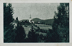
 1920s postcard of Remšnik 1920s postcard of Remšnik | |
 | |
| Coordinates: 46°38′32.95″N 15°17′10.4″E / 46.6424861°N 15.286222°E / 46.6424861; 15.286222 | |
| Country | |
| Traditional region | Styria |
| Statistical region | Carinthia |
| Municipality | Radlje ob Dravi |
| Area | |
| • Total | 5.93 km (2.29 sq mi) |
| Elevation | 851.2 m (2,792.7 ft) |
| Population | |
| • Total | 99 |
Remšnik (pronounced [ˈɾeːmʃnik]) is a dispersed settlement in the hills northeast of Radlje ob Dravi in Slovenia.
The parish church in the settlement is dedicated to Saint George and belongs to the Roman Catholic Archdiocese of Maribor. It was built on the foundations of a late Gothic church dating to 1532 after a fire in 1863 completely destroyed the original building. It is a single-nave church with a belfry on its western facade.
References
- Statistical Office of the Republic of Slovenia
- Radlje ob Dravi municipal site
- Slovenian Ministry of Culture register of national heritage reference number 3317
External links
 Media related to Remšnik at Wikimedia Commons
- Remšnik on Geopedia
| Municipality of Radlje ob Dravi | ||||||
|---|---|---|---|---|---|---|
| Settlements | Administrative seat: Radlje ob Dravi
|  | ||||
| Landmarks | ||||||
This article about the Municipality of Radlje ob Dravi in Slovenia is a stub. You can help Misplaced Pages by expanding it. |