Census-designated place & unincorporated community in Michigan, United States
| Rapid City, Michigan | |
|---|---|
| Census-designated place (CDP) & unincorporated community | |
 Post office in Rapid City Post office in Rapid City | |
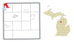
 Location within Kalkaska County Location within Kalkaska County | |
  | |
| Coordinates: 44°50′04″N 85°16′57″W / 44.83444°N 85.28250°W / 44.83444; -85.28250 | |
| Country | United States |
| State | Michigan |
| County | Kalkaska |
| Township | Clearwater |
| Area | |
| • Total | 5.53 sq mi (14.31 km) |
| • Land | 5.41 sq mi (14.01 km) |
| • Water | 0.12 sq mi (0.30 km) |
| Elevation | 630 ft (190 m) |
| Population | |
| • Total | 1,357 |
| • Density | 250.92/sq mi (96.87/km) |
| Time zone | UTC-5 (Eastern (EST)) |
| • Summer (DST) | UTC-4 (EDT) |
| ZIP code(s) | 49676 |
| Area code | 231 |
| GNIS feature ID | 635648 |
Rapid City is an unincorporated community and census-designated place (CDP) in Kalkaska County in the U.S. state of Michigan. At the 2020 census, the CDP had a population of 1,357. Rapid City is located within Clearwater Township, and is about 8 miles (13 km) northwest of Kalkaska.
History
A post office first opened in the area as Van Buren on November 22, 1892. The post office was renamed to Vanburen on January 18, 1895, and finally to Rapid City on April 30, 1898. The town is named after the Rapid River, which flows through it.
The community of Rapid City was listed as a newly organized census-designated place for the 2010 census, meaning it now has officially defined boundaries and population statistics for the first time. The CDP is organized for statistical purposes only and has no legal status as an incorporated municipality.
Geography
According to the United States Census Bureau, the community has an area of 5.50 square miles (14.24 km), of which 5.41 square miles (14.01 km) is land and 0.09 square miles (0.23 km) (1.64%) is water.
The community is located on the Rapid River, and is immediately adjacent Torch Lake. Rapid River is located on the Antrim County line.
Demographics
| Census | Pop. | Note | %± |
|---|---|---|---|
| 2010 | 1,352 | — | |
| 2020 | 1,357 | 0.4% | |
| U.S. Decennial Census | |||
| This section needs expansion. You can help by adding to it. (September 2020) |
References
- "2020 U.S. Gazetteer Files". United States Census Bureau. Retrieved May 21, 2022.
- "Rapid City". Geographic Names Information System. United States Geological Survey, United States Department of the Interior.
- ^ "2010 Census Gazetteer Files - Places: Michigan". U.S. Census Bureau. Retrieved June 1, 2018.
- "Rapid City Post Office". Geographic Names Information System. United States Geological Survey, United States Department of the Interior.
- "Michigan: 2010 Population and Housing Unit Counts 2010 Census of Population and Housing" (PDF). 2010 United States Census. United States Census Bureau. September 2012. p. 27 Michigan. Retrieved September 8, 2020.
- "Census of Population and Housing". Census.gov. Retrieved June 4, 2016.
| Municipalities and communities of Kalkaska County, Michigan, United States | ||
|---|---|---|
| County seat: Kalkaska | ||
| Village |  | |
| Civil townships | ||
| CDPs | ||
| Other communities | ||
| Footnotes | ‡This populated place also has portions in an adjacent county or counties | |
This Kalkaska County, Michigan location article is a stub. You can help Misplaced Pages by expanding it. |