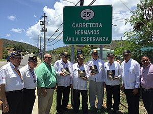
 Highway 251 Highway 251 | ||||
|---|---|---|---|---|
| Ruta 251 | ||||
| Avenida Hermanos Ávila Esperanza | ||||
| Route information | ||||
| Maintained by Puerto Rico DTPW | ||||
| Length | 2.9 km (1.8 mi) | |||
| Major junctions | ||||
| South end | ||||
| North end | Flamenco Beach in Flamenco | |||
| Location | ||||
| Country | United States | |||
| Territory | Puerto Rico | |||
| Municipalities | Culebra | |||
| Highway system | ||||
| ||||
Puerto Rico Highway 251 (PR-251) is a road located in Culebra, Puerto Rico.
Route description
Formerly known as PR-999, this road begins in front of Benjamín Rivera Noriega Airport, at its intersection with PR-250, and runs in a northwest direction in front of the Clark and Ensenada Extension communities, reaching Flamenco Beach and Laguna Flamenco. It provides indirect access to Tamarindo Beach, Flamenco Bay and Punta Molinos in the Fraile and San Isidro neighborhoods.
PR-251 was re-named Avenida Hermanos Ávila Esperanza - These six soldiers were honored for their exceptional work in the Korean and Vietnam wars and for returning home to Puerto Rico alive. Brothers (Andrés, Pedro, Norberto, Justino, Guillermo y Tomás) - The brothers also have a street named after them in Fajardo, PR (Parcelas Beltrán).
Major intersections
The entire route is located in Culebra.
| Location | km | mi | Destinations | Notes | |
|---|---|---|---|---|---|
| Culebra barrio-pueblo | 0.0 | 0.0 | Southern terminus of PR-251 | ||
| Flamenco | 2.9 | 1.8 | Northern terminus of PR-251 at Flamenco Beach; dead end road | ||
| 1.000 mi = 1.609 km; 1.000 km = 0.621 mi | |||||
See also
References
- "Ley Núm. 10 de 2016 -Para designar como Avenida Hermanos Ávila Esperanza, la Carretera Estatal PR-251 del Municipio de Culebra". LexJuris (Leyes y Jurisprudencia) de Puerto Rico (in Spanish). Retrieved 5 April 2019.
- ^ "PR-251" (Map). Google Maps. Retrieved 28 February 2020.
- National Geographic Maps (2011). Puerto Rico (Map). 1:125,000. Adventure Map (Book 3107). Evergreen, Colorado: National Geographic Maps. ISBN 978-1566955188. OCLC 756511572.
- "Culebra, Memoria Núm. 75" (PDF). Puerto Rico Planning Board (in Spanish). 1955. Retrieved 19 June 2019.
- "Plan Maestro para el Desarrollo Sustentable de Culebra" (PDF). PUERTO RICO Microjuris (in Spanish). 2004. p. 142. Retrieved 5 April 2019.
- "Orgullosos de ser veteranos". Primera Hora (in Spanish). 28 May 2007. Archived from the original on 11 May 2024. Retrieved 13 May 2024.
External links
 Media related to Puerto Rico Highway 251 at Wikimedia Commons
This Culebra, Puerto Rico location article is a stub. You can help Misplaced Pages by expanding it. |
This Puerto Rico road-related article is a stub. You can help Misplaced Pages by expanding it. |
