Village in Newfoundland and Labrador, Canada
| Pool's Cove | |
|---|---|
| Village | |
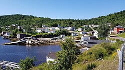
 Fishing Village of Pool's Cove from a Hill Fishing Village of Pool's Cove from a Hill | |
 | |
| Coordinates: 47°40′47.70″N 55°25′52.45″W / 47.6799167°N 55.4312361°W / 47.6799167; -55.4312361 | |
| Country | |
| Province | |
| Population | |
| • Total | 143 |
| • Density | 73.1/km (189/sq mi) |
| Time zone | UTC-3:30 (Newfoundland Time) |
| • Summer (DST) | UTC-2:30 (Newfoundland Daylight) |
| Area code | 709 |
| Highways | Route 362-10 |
Pool's Cove is a fishing village located on the north west side of Fortune Bay, on the South Coast of Newfoundland, Canada. The town had a population of 143 in the 2021 Census.
History & Town Information
Historically, Pool's Cove has been an important location for the local fishing industry, and while fishing remains a part of its economy, the town has diversified in recent years especially in the logging industry.
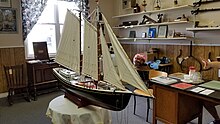
Pool's Cove boasts a community museum that showcases the local history and heritage, including the stories of nearby resettled communities.

The village is also the gateway to the Bay du Nord River, a designated Canadian Heritage River, which offers opportunities for backcountry wilderness recreation, including canoeing, kayaking, angling, and birdwatching.
The current town mayor as of 2024 is Edmund Perham.
Demographics
In the 2021 Census of Population conducted by Statistics Canada, Pool's Cove had a population of 143 living in 62 of its 75 total private dwellings, a change of -25.9% from its 2016 population of 193. With a land area of 2.65 km (1.02 sq mi), it had a population density of 54.0/km (139.8/sq mi) in 2021.
Navigating
Pool's Cove is located on the Connaigre Peninsula, and can be accessed by driving or taking the passenger ferry from Bay L'Argent on the Burin Peninsula. Access to Pool's Cove is quite unique as it is one of the stops on the ferry route connecting Bay L'Argent to Rencontre East. The ferry service is passenger-only, meaning no vehicles are allowed.


References
- ^ "Population and dwelling counts: Canada, provinces and territories, census divisions and census subdivisions (municipalities), Newfoundland and Labrador". Statistics Canada. February 9, 2022. Retrieved March 15, 2022.
- Newfoundland and Labrador, District Office (2019). "Newfoundland and Labrador Logging in South Coast" (PDF).
- ^ "Pool's Cove". Bob's Newfoundland. Retrieved 2024-05-20.
- Newfoundland and Labrador, Government. "Newfoundland and Labrador Mayor Information" (PDF).
- "Touring Newfoundland's Connaigre Peninsula". Cape Breton Post. Saltwire Network. November 17, 2016. Archived from the original on 7 July 2019. Retrieved October 21, 2019.
- "N.L. ferries made 4,100 trips with no passengers last year". CBC. 2020-05-15. Retrieved 2020-12-17.
- "Newfoundland and Labrador, Canada – Official Tourism Website". Newfoundland and Labrador, Canada – Official Tourism Website. Retrieved 2024-05-20.
| Fortune Bay | |
|---|---|
| Settlements | |
| Division No. 3, Newfoundland and Labrador (South Coast) | |
|---|---|
| Towns | |
| First Nations | |
| Indian reserves | |
| Unorganized subdivisions | |
| Designated places | |
This Newfoundland and Labrador location article is a stub. You can help Misplaced Pages by expanding it. |