Suburb in Western Province, Sri Lanka
| Pettah | |
|---|---|
| Suburb | |
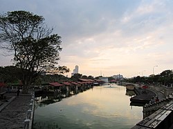
 Pettah Floating Market at dusk Pettah Floating Market at dusk | |
   | |
| Coordinates: 6°56′12″N 79°50′59″E / 6.93667°N 79.84972°E / 6.93667; 79.84972 | |
| Country | Sri Lanka |
| Province | Western Province |
| District | Colombo District 11 |
| Time zone | UTC+05:30 (Sri Lanka Standard Time Zone) |
| Postal Code | 01100 |
| Website | pettah |
Pettah (Sinhala: පිටකොටුව (Piṭakoṭuva), Tamil: புறக்கோட்டை (Puṟakkōṭṭai)) is a neighbourhood in Colombo, Sri Lanka, located east of the city centre Fort, and behind the Colombo Port. The Pettah neighborhood is famous for the Pettah Market, a series of open air bazaars and markets. It is one of Sri Lanka's busiest commercial areas, where a huge number of wholesale and retail shops, buildings, commercial institutions and other organisations are located.
The main market segment is designed like a gigantic crossword puzzle, where one may traverse through the entire markets from dawn till dusk, but not completely cover every part of it.
Pettah is derived from Tamil: Pettai, an Anglo-Indian word used to indicate a suburb outside a fort. Today, the Sinhala phrase, pita-kotuwa (outside the fort) conveniently describes the same place.
Demographics
Pettah is a multi-religious and multi-ethnic area. Moors, Bohras and Memons are the predominant ethnic group found within Pettah, however an average amount of Sinhalese and Tamil populations also exist. There are also various other minorities, such as Burghers, Malays and others. Religions include Buddhism, Hinduism, Islam, Christianity and various other religions and beliefs to a lesser extent.
Buildings and landmarks
Notable landmarks in the neighborhood include:
- Wolvendaal Church
- Jami Ul-Alfar Mosque
- Kayman's Gate
- Former Colombo Town Hall
- Colombo Dutch Museum
- Sammangodu Sri Kathirvelayutha Swami Kovil
- Old Town Hall Market
- Federation of Self Employees Market
- Manning Market
- Pettah Floating Market
- Cross Street Bazaars
- Central Bus Station
- Khan Clock Tower
-
 One of the streets that make up the Pettah Market.
-
 One of the streets that make up the Pettah Market
-
 One of the streets that make up the Pettah Market
| Places adjacent to Pettah, Sri Lanka | ||||||||||||||||
|---|---|---|---|---|---|---|---|---|---|---|---|---|---|---|---|---|
| ||||||||||||||||
References
- "Pettah Post Office - Sri Lanka Postal Codes". Mohanjith. Archived from the original on 5 September 2012. Retrieved 11 April 2013.
- "Sri Lanka - Travel Information - Colombo Pettah". Lankainfo.com. Archived from the original on 24 March 2013. Retrieved 11 April 2013.
- "Colombo, The Famous Business Hub of Sri Lanka – Stories & Advice". Retrieved 20 December 2018.
- "A Walk Through Pettah". Sunday Observer. 18 March 2007. Archived from the original on 14 July 2014. Retrieved 24 June 2014.
This Western Province, Sri Lanka location article is a stub. You can help Misplaced Pages by expanding it. |