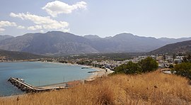
| Pacheia Ammos Παχειά Άμμος | |
|---|---|
| Community | |
 | |
 | |
| Coordinates: 35°06′32″N 25°48′18″E / 35.109°N 25.805°E / 35.109; 25.805 | |
| Country | Greece |
| Administrative region | Crete |
| Regional unit | Lasithi |
| Municipality | Ierapetra |
| Municipal unit | Ierapetra |
| Population | |
| • Community | 827 |
| Time zone | UTC+2 (EET) |
| • Summer (DST) | UTC+3 (EEST) |
Pacheia Ammos (Greek: Παχειά Άμμος) is a village in the municipality of Ierapetra on the island of Crete in Greece. It is located on the north coast of the island, 15 km to the north of the city of Ierapetra, at the fork in the road that leads to Heraklion in the west and Sitia in the east.
Attractions
- The Minoan settlement of Gournia
- The Minoan settlement of Vasiliki
- The church of Agios Nikolaos
- The church of Agios Analipsi
- The INSTAP study center
References
- "Αποτελέσματα Απογραφής Πληθυσμού - Κατοικιών 2021, Μόνιμος Πληθυσμός κατά οικισμό" [Results of the 2021 Population - Housing Census, Permanent population by settlement] (in Greek). Hellenic Statistical Authority. 29 March 2024.
| Subdivisions of the municipality of Ierapetra | |
|---|---|
| Municipal unit of Ierapetra | |
| Municipal unit of Makry Gialos | |
This Crete location article is a stub. You can help Misplaced Pages by expanding it. |