| This article needs additional citations for verification. Please help improve this article by adding citations to reliable sources. Unsourced material may be challenged and removed. Find sources: "Ozark Trail" auto trail – news · newspapers · books · scholar · JSTOR (March 2008) (Learn how and when to remove this message) |
| Ozark Trail | |
|---|---|
 A map showing routes adopted (red) and others promoted (white) by the Ozark Trails Association A map showing routes adopted (red) and others promoted (white) by the Ozark Trails Association | |
| Route information | |
| Existed | 1913–1925 |
| Major junctions | |
| Northeast end | St. Louis, Missouri |
| Southwest end | |
| Location | |
| Country | United States |
| States | Missouri, Oklahoma, Texas, New Mexico |
| Highway system | |
The Ozark Trail was a network of locally maintained roads and highways organized by the Ozark Trails Association that predated the United States federal highway system. The roads ran from St. Louis, Missouri, to El Paso, Texas, and Santa Fe, New Mexico, over a series of routes. These roads were maintained by both private citizens and local communities. In one case, however, the U.S. government was directly involved; it built the Newcastle Bridge in 1923 over the South Canadian River between Newcastle, Oklahoma, and Oklahoma City, as the first federal highway project built in Oklahoma.
These roads comprised the major highway system in the region until U.S. Highway 66 was built in the 1920s. In Oklahoma, portions of the section-line roads between Anadarko and Hobart are still referred to as "The Old Ozark Trail."

Route

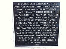
The Ozark Trails Association were a group of private citizens that tried to encourage local municipalities to build and maintain road systems in the Ozarks in the early 20th century. It was established in 1913. They erected large obelisks marking the various roads and indicated distances to various towns and communities. Twenty-one were constructed and of those only 7 still remain in existence, at Stroud, Oklahoma, Farwell, Dimmitt, Wellington, and Tulia, Texas. The Ozark Trail ran through southwest Missouri and across Oklahoma, the Texas panhandle, and on into New Mexico. Much of this route became the famed U.S. Route 66. The Federal Aid Highway Act of 1925, which finally incorporated the Deep South into the Federal roads program, made the group's basic functions obsolete and it disbanded.
William Hope "Coin" Harvey was closely associated with the organization.
References
- Archived 2007-03-09 at the Wayback Machine "Ozark Trail", Ohio State University-Marion
- "Oklahoma Historical Society". 2020-04-21.
- "Four States Build Road". Robinson Constitution. Robinson, Crawford County, Illinois. October 15, 1913. Retrieved 30 April 2010.
- "Ozark Trails Men Arrive At No Decision". The Christian Science Monitor. August 14, 1916. Archived from the original on October 26, 2012. Retrieved 30 April 2010.
Nearly 2000 persons attended the annual convention of the Ozark Trails Association...
- "Ozark Trail Plans New Travel Route". The Christian Science Monitor. Boston, Mass. July 1, 1916. Archived from the original on October 26, 2012. Retrieved 30 April 2010.
- "Knew "Coin" Harvey". The Southeast Missourian. Cape Girardeau, Missouri. February 12, 1936. Retrieved 30 April 2010.
Mr. Harvey was a booster for good roads for tears, particularly in northwest Arkansas and southwest MIssouri.
External links
- http://www.nps.gov/history/rt66/HistSig/New%20Mexico.htm
- http://www.drivetheost.com/ozarktrails.html
- http://www.drivetheost.com/williamhopeharve.html
- http://www.drivetheost.com/ozarkmap.html Archived 2012-04-16 at the Wayback Machine
- http://www.drivetheost.com/otmarkergallery.html
- http://www.okladot.state.ok.us/hqdiv/p-r-div/spansoftime/roadsystem.htm