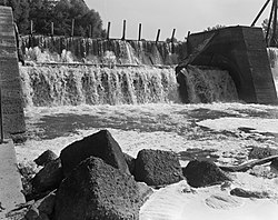
| Ouachita River Lock and Dam No. 8 | |
| U.S. National Register of Historic Places | |
 | |
  | |
| Nearest city | Calion, Arkansas |
|---|---|
| Coordinates | 33°17′59.8″N 92°27′53.2″W / 33.299944°N 92.464778°W / 33.299944; -92.464778 |
| Area | 11.3 acres (4.6 ha) |
| Built | 1907 (1907) |
| Architect | U.S. Army Corps of Engineers |
| NRHP reference No. | 83003458 |
| Added to NRHP | December 19, 1983 |
The Ouachita River Lock and Dam No. 8 are a historic lock and dam on the Ouachita River in Calhoun County, Arkansas. The area is managed by the county and the Arkansas Fish and Game Commission as a public recreation area. The facility offers a boat ramp and a few campsites.
The lock and dam were listed on the National Register of Historic Places in 1983.
See also
References
- ^ "National Register Information System". National Register of Historic Places. National Park Service. July 9, 2010.
- "Ouachita-Black River Area". US Army Corps of Engineers. Retrieved 2014-01-18.
External links
- Historic American Engineering Record (HAER) No. AR-1, "Ouachita River Lock & Dam No. 8, Ouachita River at River Mile 282.8, Calion, Union County, AR", 49 photos, 6 data pages, 3 photo caption pages
| U.S. National Register of Historic Places | |
|---|---|
| Topics | |
| Lists by state |
|
| Lists by insular areas | |
| Lists by associated state | |
| Other areas | |
| Related | |
This article about a property in Calhoun County, Arkansas on the National Register of Historic Places is a stub. You can help Misplaced Pages by expanding it. |
- United States Army Corps of Engineers dams
- Transportation buildings and structures on the National Register of Historic Places in Arkansas
- Buildings and structures completed in 1907
- Dams completed in 1907
- Dams in the Mississippi River basin
- Historic American Engineering Record in Arkansas
- National Register of Historic Places in Calhoun County, Arkansas
- Locks on the National Register of Historic Places
- Dams on the National Register of Historic Places in Arkansas
- 1907 establishments in Arkansas
- Ouachita River
- Southwest Arkansas Registered Historic Place stubs