| The topic of this article may not meet Misplaced Pages's general notability guideline. Please help to demonstrate the notability of the topic by citing reliable secondary sources that are independent of the topic and provide significant coverage of it beyond a mere trivial mention. If notability cannot be shown, the article is likely to be merged, redirected, or deleted. Find sources: "Oconee Rivers Greenway Network" – news · newspapers · books · scholar · JSTOR (July 2022) (Learn how and when to remove this message) |

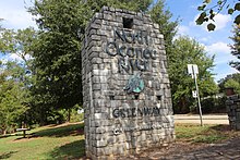
The North Oconee River Greenway Network is a system of linear parks and trails constituting a total of 8 paved miles in Athens, Georgia. It consists of a mixture of unpaved and paved multi-use trails abutting the Oconee River, some of its minor tributaries and other parks within the county. The network continues to be expanded primarily through the use of TSPLOST funding in addition to funding from Georgia Department of Transportation. The network utilizes a mixture of rail-to-trail and riparian right of ways.
History
The first trail of the network, Cook's Trail, was built in the 1990's and consisted of 4.1 miles of unpaved trail and boardwalk and connected Sandy Creek Nature Center with Sandy Creek Park. The trail was named for a retired University of Georgia professor in forestry, Walt Cook, a major figure in the founding of the Sandy Creek Nature Center.
More recently, proponents and local officials seek to use the network to improve equity in historically underserved neighborhood and to increase connectivity and safety in the Athens area.

Greenways, multi-use paths and trails in the network
The North Oconee River Greenway paved 3.5-miles long a 10-foot wide multi-use path for non-motorized traffic running from Sandy Creek Nature Center, where it connected with Cook's Greenway Trail, south to Dudley Park. The greenway connects to the University of Georgia's own network of multi-use trails and paths on campus. The North Oconee River Greenway is currently being expanded through Oconee Hill Cemetery.
The Trail Creek Trail is a paved multi-use trail connecting to Virginia Walker Park.
The Firefly Trail, begun around 2017, is a cycling-pedestrian route built on top of an abandoned railway that will eventually support transport from Dudley Park to Winterville.
References
- Owens, Lindsay (April 21, 2022). "9 Athens-area trails to explore on Earth Day". The Red & Black.
- Shearer, Lee (August 12, 2017). "Cook's Trail open again, connecting Sandy Creek nature center and park". Athens Banner-Herald. Retrieved July 16, 2022.
- "North Oconee River Greenway | Georgia Trails | TrailLink".
- ^ Shearer, Lee (May 18, 2017). "Projects will add more miles to North Oconee Greenway". Athens Banner-Herald.
- Ford, Wayne (April 6, 2022). "Historic steel bridge in Oconee Hill Cemetery in Athens closed until July for repairs". Athens Banner-Herald.
External links
| Athens, Georgia | |||||
|---|---|---|---|---|---|
| Topics |
| ||||
| Businesses | |||||
| Colleges and Universities | |||||
| K–12 education |
| ||||
| Arts and culture | |||||
| Venues | |||||
| Sports | |||||
| Tourist attractions | |||||
| Radio stations | |||||
Categories: