| New Barag Left Banner 新巴尔虎左旗 • ᠰᠢᠨᠡ ᠪᠠᠷᠭᠤ ᠵᠡᠭᠦᠨ ᠬᠣᠰᠢᠭᠤ | |
|---|---|
| Banner | |
 | |
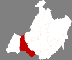
 Location in Hulunbuir Location in Hulunbuir | |
  | |
| Coordinates: 48°13′N 118°16′E / 48.217°N 118.267°E / 48.217; 118.267 | |
| Country | China |
| Autonomous region | Inner Mongolia |
| Prefecture-level city | Hulunbuir |
| Banner seat | Amgalang |
| Area | |
| • Total | 20,107.18 km (7,763.43 sq mi) |
| Elevation | 648 m (2,126 ft) |
| Population | |
| • Total | 37,007 |
| • Density | 1.8/km (4.8/sq mi) |
| Time zone | UTC+8 (China Standard) |
| Website | www |
| New Barag Left Banner | |||||||
|---|---|---|---|---|---|---|---|
| Chinese name | |||||||
| Simplified Chinese | 新巴尔虎左旗 | ||||||
| Traditional Chinese | 新巴爾虎左旗 | ||||||
| |||||||
| Mongolian name | |||||||
| Mongolian Cyrillic | Шинэ Барга зүүн хошуу | ||||||
| Mongolian script | ᠰᠢᠨᠡ ᠪᠠᠷᠭᠤ ᠵᠡᠭᠦᠨ ᠬᠣᠰᠢᠭᠤ | ||||||
| |||||||
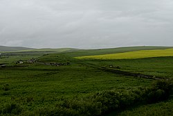
New Barag Left Banner (Mongolian: ᠰᠢᠨᠡ ᠪᠠᠷᠭᠤ ᠵᠡᠭᠦᠨ ᠬᠣᠰᠢᠭᠤ; Chinese: 新巴尔虎左旗) is a banner of Inner Mongolia, China, bordering Mongolia to the south. It is under the administration of Hulunbuir City.
Administrative divisions
New Barag Left Banner is made up of 2 towns and 5 ethnic sums.
| Name | Simplified Chinese | Hanyu Pinyin | Mongolian (Hudum Script) | Mongolian (Cyrillic) | Administrative division code |
|---|---|---|---|---|---|
| Towns | |||||
| Qagan Town | 嵯岗镇 | Cuógǎng Zhèn | ᠴᠠᠭᠠᠨ ᠪᠠᠯᠭᠠᠰᠤ | Цагаан балгас | 150726101 |
| Amgalang Town | 阿木古郎镇 | Āmùgǔláng Zhèn | ᠠᠮᠤᠭᠤᠯᠠᠩ ᠪᠠᠯᠭᠠᠰᠤ | Амгалан балгас | 150726102 |
| Sums | |||||
| Xin Bulag Sum | 新宝力格苏木 | Xīnbǎolìgé Sūmù | ᠰᠢᠨᠡᠪᠤᠯᠠᠭ ᠰᠤᠮᠤ | Шинэбулаг сум | 150726202 |
| Obor Bulag Sum | 乌布尔宝力格苏木 | Wūbù'ěrbǎolìgé Sūmù | ᠥᠪᠥᠷᠪᠤᠯᠠᠭ ᠰᠤᠮᠤ | Өвөрбулаг сум | 150726203 |
| Handgai Sum | 罕达盖苏木 | Hǎndágài Sūmù | ᠬᠠᠨᠳᠠᠭᠠᠢ ᠰᠤᠮᠤ | Хандгай сум | 150726204 |
| Jibhlangt Sum | 吉布胡郎图苏木 | Jíbùhúlángtú Sūmù | ᠵᠢᠪᠬᠤᠯᠠᠩᠲᠤ ᠰᠤᠮᠤ | Жавхлант сум | 150726205 |
| Ganjur Sum | 甘珠尔苏木 | Gānzhū'ěr Sūmù | ᠭᠠᠨᠵᠤᠤᠷ ᠰᠤᠮᠤ | Ганжуур сум | 150726206 |
Climate
| Climate data for New Barag Left Banner, elevation 642 m (2,106 ft), (1991–2020 normals, extremes 1981–2010) | |||||||||||||
|---|---|---|---|---|---|---|---|---|---|---|---|---|---|
| Month | Jan | Feb | Mar | Apr | May | Jun | Jul | Aug | Sep | Oct | Nov | Dec | Year |
| Record high °C (°F) | −0.9 (30.4) |
7.7 (45.9) |
19.8 (67.6) |
30.7 (87.3) |
36.2 (97.2) |
40.4 (104.7) |
40.9 (105.6) |
39.0 (102.2) |
33.8 (92.8) |
27.0 (80.6) |
13.2 (55.8) |
1.8 (35.2) |
40.9 (105.6) |
| Mean daily maximum °C (°F) | −17.8 (0.0) |
−12.0 (10.4) |
−1.8 (28.8) |
10.7 (51.3) |
19.6 (67.3) |
25.9 (78.6) |
27.9 (82.2) |
25.9 (78.6) |
19.2 (66.6) |
8.9 (48.0) |
−4.5 (23.9) |
−15.2 (4.6) |
7.2 (45.0) |
| Daily mean °C (°F) | −23.0 (−9.4) |
−18.3 (−0.9) |
−8.3 (17.1) |
3.9 (39.0) |
12.7 (54.9) |
19.4 (66.9) |
22.0 (71.6) |
19.7 (67.5) |
12.4 (54.3) |
2.3 (36.1) |
−10.3 (13.5) |
−20.1 (−4.2) |
1.0 (33.9) |
| Mean daily minimum °C (°F) | −27.1 (−16.8) |
−23.2 (−9.8) |
−13.9 (7.0) |
−2.3 (27.9) |
5.7 (42.3) |
12.9 (55.2) |
16.4 (61.5) |
14.2 (57.6) |
6.7 (44.1) |
−2.8 (27.0) |
−14.7 (5.5) |
−24.1 (−11.4) |
−4.4 (24.2) |
| Record low °C (°F) | −40.8 (−41.4) |
−39.3 (−38.7) |
−31.0 (−23.8) |
−22.8 (−9.0) |
−7.5 (18.5) |
0.4 (32.7) |
5.7 (42.3) |
2.6 (36.7) |
−5.8 (21.6) |
−19.7 (−3.5) |
−32.4 (−26.3) |
−38.0 (−36.4) |
−40.8 (−41.4) |
| Average precipitation mm (inches) | 3.2 (0.13) |
2.5 (0.10) |
5.6 (0.22) |
11.4 (0.45) |
19.2 (0.76) |
44.1 (1.74) |
77.2 (3.04) |
64.3 (2.53) |
31.1 (1.22) |
12.6 (0.50) |
6.2 (0.24) |
5.9 (0.23) |
283.3 (11.16) |
| Average precipitation days (≥ 0.1 mm) | 5.8 | 4.3 | 4.6 | 5.1 | 6.7 | 9.7 | 12.5 | 10.6 | 7.7 | 5.8 | 6.3 | 7.9 | 87 |
| Average snowy days | 8.3 | 5.9 | 7.3 | 5.2 | 0.9 | 0.1 | 0 | 0 | 0.6 | 4.6 | 9.1 | 10.4 | 52.4 |
| Average relative humidity (%) | 75 | 73 | 63 | 44 | 41 | 50 | 60 | 61 | 56 | 56 | 69 | 76 | 60 |
| Mean monthly sunshine hours | 171.7 | 201.7 | 263.3 | 255.3 | 281.3 | 285.3 | 277.1 | 258.6 | 242.4 | 212.4 | 161.8 | 148.2 | 2,759.1 |
| Percent possible sunshine | 62 | 69 | 71 | 62 | 60 | 60 | 58 | 59 | 65 | 64 | 59 | 57 | 62 |
| Source: China Meteorological Administration | |||||||||||||
References
- Inner Mongolia: Prefectures, Cities, Districts and Counties
- "Snowboarding lover in Hulun Buir, N China". China Internet Information Center. January 18, 2023.
New Barag Left Banner
- 中国气象数据网 – WeatherBk Data (in Simplified Chinese). China Meteorological Administration. Retrieved 10 October 2023.
- 中国气象数据网 (in Simplified Chinese). China Meteorological Administration. Retrieved 10 October 2023.
- www.xzqh.org (in Chinese)
| County-level divisions of Inner Mongolia Autonomous Region | |||||||||||||||||||
|---|---|---|---|---|---|---|---|---|---|---|---|---|---|---|---|---|---|---|---|
| Hohhot (capital) | |||||||||||||||||||
| Prefecture-level cities |
| ||||||||||||||||||
| Leagues |
| ||||||||||||||||||
This Inner Mongolia location article is a stub. You can help Misplaced Pages by expanding it. |