| This article does not cite any sources. Please help improve this article by adding citations to reliable sources. Unsourced material may be challenged and removed. Find sources: "Neunkircher Höhe" – news · newspapers · books · scholar · JSTOR (September 2018) (Learn how and when to remove this message) |
| Neunkircher Höhe | |
|---|---|
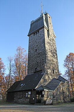
 Viewing tower on the top of the Neunkircher Höhe Viewing tower on the top of the Neunkircher Höhe | |
| Highest point | |
| Elevation | 605 m (1,985 ft) |
| Coordinates | 49°43′8″N 8°46′13″E / 49.71889°N 8.77028°E / 49.71889; 8.77028 |
| Naming | |
| English translation | Nine churches height |
| Language of name | German |
| Geography | |
 | |
| Location | Hesse, Germany |
| Parent range | Odenwald |
The Neunkircher Höhe (605 metres) is the highest elevation of the Hessian part of the Odenwald. The hill is located near the village Neunkirchen and is the origin of the rivers Modau, Gersprenz and Lauter.
A viewing tower, 34 metres high, was built on the summit in 1906 and replaced an older predecessor, which had been built in 1888 and destroyed by a storm in 1904.
This Hesse location article is a stub. You can help Misplaced Pages by expanding it. |