Town in Queensland, Australia
| Midgenoo Queensland | |||||||||||||||
|---|---|---|---|---|---|---|---|---|---|---|---|---|---|---|---|
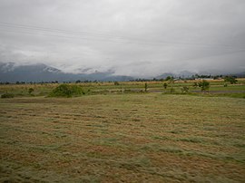
 View across the fields to distant mountains, Midgenoo, 2013 View across the fields to distant mountains, Midgenoo, 2013 | |||||||||||||||
 | |||||||||||||||
| Coordinates | 17°53′41″S 145°57′38″E / 17.8947°S 145.9605°E / -17.8947; 145.9605 (Midgenoo (town centre)) | ||||||||||||||
| Population | 76 (2021 census) | ||||||||||||||
| • Density | 10.13/km (26.2/sq mi) | ||||||||||||||
| Postcode(s) | 4854 | ||||||||||||||
| Area | 7.5 km (2.9 sq mi) | ||||||||||||||
| Time zone | AEST (UTC+10:00) | ||||||||||||||
| Location |
| ||||||||||||||
| LGA(s) | Cassowary Coast Region | ||||||||||||||
| State electorate(s) | Hill | ||||||||||||||
| Federal division(s) | Kennedy | ||||||||||||||
| |||||||||||||||
Midgenoo is a rural town and locality in the Cassowary Coast Region, Queensland, Australia. In the 2021 census, the locality of Midgenoo had a population of 76 people.
Geography
The town is north of centre within the locality. This land is flat (approx 20 metres above sea level) and is used for crops, principally sugarcane.
The Bruce Highway and North Coast railway line traverse the locality from south-west to north, passing through the town. Midgenoo railway station (17°53′44″S 145°57′40″E / 17.8955°S 145.9611°E / -17.8955; 145.9611 (Midgenoo railway station)) once served the town but now is abandoned. There are also sugarcane tramways in the locality.
History

The town's name Midgenoo is taken from the Midgenoo railway station and is reportedly an Aboriginal word for a local tree.
Midgenoo State School opened in 1923 and closed in 1933.
Demographics
In the 2016 census, the locality of Midgenoo had a population of 51 people.
In the 2021 census, the locality of Midgenoo had a population of 76 people.
Education
There are no schools in Midgneoo. The nearest government primary school is Feluga State School in neighbouring Feluga to the north. The nearest government secondary school is Tully State High School in Tully to the south. There is also a Catholic primary school in Tully.
References
- ^ Australian Bureau of Statistics (28 June 2022). "Midgenoo (SAL)". 2021 Census QuickStats. Retrieved 28 February 2023.

- ^ "Midgenoo – town in Cassowary Coast Region (entry 22010)". Queensland Place Names. Queensland Government. Retrieved 26 December 2020.
- "Midgenoo – locality in Cassowary Coast Region (entry 45730)". Queensland Place Names. Queensland Government. Retrieved 26 December 2020.
- ^ "Queensland Globe". State of Queensland. Retrieved 30 July 2017.
- "Midgenoo – railway station in Cassowary Coast Region (entry 22011)". Queensland Place Names. Queensland Government. Retrieved 30 July 2017.
- "Railway stations and sidings - Queensland". Queensland Open Data. Queensland Government. 2 October 2020. Archived from the original on 5 October 2020. Retrieved 5 October 2020.
- Queensland Family History Society (2010), Queensland schools past and present (Version 1.01 ed.), Queensland Family History Society, ISBN 978-1-921171-26-0
- Australian Bureau of Statistics (27 June 2017). "Midgenoo (SSC)". 2016 Census QuickStats. Retrieved 20 October 2018.

- "Layers: Locality; Schools and school catchments". Queensland Globe. Queensland Government. Archived from the original on 19 December 2017. Retrieved 21 December 2024.
External links