| Mashavera | |
|---|---|
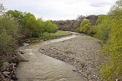
 The Mashavera in Bolnisi The Mashavera in Bolnisi | |
| Native name | მაშავერა (Georgian) |
| Location | |
| Country | Georgia |
| Physical characteristics | |
| Mouth | Khrami |
| • coordinates | 41°26′11″N 44°42′54″E / 41.4364°N 44.7150°E / 41.4364; 44.7150 |
| Length | 66 km (41 mi) |
| Basin size | 1,390 km (540 sq mi) |
| Basin features | |
| Progression | Khrami→ Kura→ Caspian Sea |
The Mashavera (Georgian: მაშავერა) is a river of southern Georgia. It is 66 km (41 mi) long, and has a 1,390 km (540 sq mi) drainage basin. It is a right tributary of the Khrami, which in turn is a tributary of the Kura. It flows through the towns of Dmanisi and Bolnisi.
References
- Statistical Yearbook of Georgia: 2020, National Statistics Office of Georgia, Tbilisi, 2020, p. 12.
| Black sea basin | |
|---|---|
| Caspian basin | |
| Note: † also known as Kura ‡ also known as Terek List of rivers of Georgia (country) | |
This article related to a river in Georgia is a stub. You can help Misplaced Pages by expanding it. |