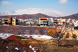
| Mas'ade
مسعدة מסעדה | |
|---|---|
| Town | |
 | |
  | |
| Coordinates: 33°13′59″N 35°45′27″E / 33.23306°N 35.75750°E / 33.23306; 35.75750 | |
| Country | Golan Heights, internationally recognized as Syrian territory occupied by Israel. See Status of the Golan Heights. |
| Israeli District | Northern District |
| Israeli Subdistrict | Golan Subdistrict |
| Syrian Governorate | Quneitra Governorate |
| Syrian District | Quneitra District |
| Syrian Subdistrict | Mas'ade Subdistrict |
| Population | |
| • Total | 3,869 |
Mas'ade (Arabic: مسعدة, Hebrew: מַסְעַדֶה) is a Druze village in the northern Golan Heights. It covers an area of 11,985 dunams (11.985 km; 4.627 sq mi), and in 2022 had a population of 3,869. It was given the status of a local council in 1982. Its inhabitants are mostly Syrian citizens and have permanent residency in Israel. Since the adoption of the 1981 Golan Heights Law, Mas'ade is under Israeli civil law and is incorporated into the Israeli system of local councils.
The presence of Druze around Mount Hermon is documented since the founding of the Druze religion in the beginning of the 11th century. Mas'ade is one of the four remaining Druze-Syrian communities on the Israeli-occupied side of the Golan Heights and on Mount Hermon, together with Majdal Shams, Ein Qiniyye and Buq'ata. Geographically a distinction is made between the Golan Heights and Mount Hermon, the boundary being marked by the Sa'ar Stream; however, administratively they are usually lumped together. Mas'ade and Buq'ata are on the Golan side of the boundary and are characterized by black volcanic rock (basalt), while Majdal Shams and Ein Qiniyye are on the Hermon side, thus sitting on limestone.
Near Mas'ade are Lake Ram and Odem Forest [he].
Mas'ade is located at the intersection of Route 99, which leads west to Kiryat Shmona, and Route 98, which leads north to Mount Hermon and south to the Kinneret (Sea of Galilee/Lake Tiberias).
References
- "Regional Statistics". Israel Central Bureau of Statistics. Retrieved 21 March 2024.
- Roy Marom, “Sukayk and al-Summāqah: Mamluk Rural Geography in the Northern Jawlān/Golan Heights in the Light of Qāytbāy’s Endowment Deeds,” in Kate Raphael and Mustafa Abbasi (ed.s), The Golan in the Mamluk and Ottoman Periods: an Archaeological and Historical Study: Excavations at Naʿarān and Farj, In Honour of Moshe Hartal, Yigal Ben Ephraim and Shuqri ‘Arraf, Annual of the Nelson Glueck School of Biblical Archaeology Hebrew Union College—Jewish Institute of Religion Volume xiv (2024): 67
| Quneitra Governorate of Syria | |||||||||
|---|---|---|---|---|---|---|---|---|---|
| Quneitra District |
| ||||||||
| Fiq District | |||||||||
| Syrian localities in Israeli-occupied Golan Heights |
| ||||||||
| Israeli settlements in the Israeli-occupied Golan Heights |
| ||||||||
| Israeli settlements in italics were on the Mandatory Palestine side of the 1923 border. | |||||||||
This geography of Israel article is a stub. You can help Misplaced Pages by expanding it. |
This article about a location in Quneitra Governorate, Syria is a stub. You can help Misplaced Pages by expanding it. |
