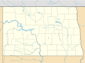
Map all coordinates using OpenStreetMap
Download coordinates as:
There are 4 National Natural Landmarks in North Dakota.

| Name | Image | Date | Location | County | Ownership | Description |
|---|---|---|---|---|---|---|
| Fischer Lake | 1960 | 47°05′00″N 99°13′38″W / 47.083268°N 99.227339°W / 47.083268; -99.227339 (Fischer Lake) | Stutsman | mixed- state & private | Representative of the glacial moraine and pitted outwash plain surface of North Dakota. | |
| Rush Lake | 1965 | 48°54′16″N 98°40′53″W / 48.904575°N 98.681398°W / 48.904575; -98.681398 (Rush Lake) | Cavalier | private | A large shallow, essentially undisturbed prairie pothole lake. | |
| Sibley Lake | 1975 | 47°31′13″N 98°20′43″W / 47.520278°N 98.345278°W / 47.520278; -98.345278 (Sibley Lake) | Kidder | mixed- state & private | A large, permanent alkaline lake. | |
| Two Top and Big Top Mesa | 1965 | 47°18′08″N 103°29′16″W / 47.302222°N 103.487778°W / 47.302222; -103.487778 (Two Top and Big Top Mesa) | Billings | federal (Little Missouri National Grassland) | A badlands terrain of sandstones, siltstones and clay. |
See also
References
- "National Natural Landmarks - National Natural Landmarks (U.S. National Park Service)". www.nps.gov. Retrieved 2019-03-26.
There are four National Natural Landmark sites located within the state of North Dakota.