| Lake Sibinacocha | |
|---|---|
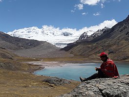
 Lake Sibinacocha with Chumpe in the background Lake Sibinacocha with Chumpe in the background | |
 | |
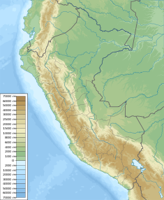
| Location | Cusco Region |
| Coordinates | 13°51′24″S 71°01′30″W / 13.85667°S 71.02500°W / -13.85667; -71.02500 |
| Basin countries | Peru |
| Max. length | 15.19 km (9.44 mi) |
| Max. width | 2.86 km (1.78 mi) |
| Surface elevation | 4,873 m (15,988 ft) |
| Website | The Sibinacocha Watershed Project |
| Sibinacocha Dam | |
|---|---|
 | |
 | |
| Opening date | 1996 |
| Dam and spillways | |
| Type of dam | Earthen dam |
| Height | 12 m (39 ft) |
| Length | 357 m (1,171 ft) |
| Reservoir | |
| Total capacity | 110,000,000 m (89,000 acre⋅ft) |
| Power Station | |
| Operator(s) | EGEMSA |
| Website Represa de Sibinacocha | |
Lake Sibinacocha (possibly from Quechua siwina whistle, qucha lake, lagoon) is a lake in Peru. It is ranked as the 22nd highest lake in the world. It is located in the Cusco Region, Canchis Province, Pitumarca District. The lake is situated at a height of approximately 4,873 metres (15,988 ft), about 15.19 km long and 2.86 km at its widest point, and drains into the Amazon River. Sibinacocha lies in the Vilcanota Range, south of Chumpe and southwest of Condoriquiña.
The lake contains Inca artifact, some of which have been recovered from the lake. Sacred sites around the lake have been studied as possible locations of the lost Ausangate temple. The area has been studied for its importance to the greater Urubamba-Vilcanota watershed. A high-altitude diver, Geoffrey Belter, died in 2014 while exploring the lake.
An earthen dam was erected at the lake in 1996. It is 357 m (1,171 ft) long and 12 m (39 ft) high. The reservoir has a volume of 50,000 m (41 acre⋅ft) and a capacity of 110,000,000 m (89,000 acre⋅ft). It is operated by EGEMSA.
See also
References
- ^ Peru 1:100 000, Ocongate (28-t). IGN (Instituto Geográfico Nacional - Perú).
- ^ escale.minedu.gob.pe - UGEL map of the Canchis Province (Cusco Region)
- Teofilo Laime Ajacopa (2007). Diccionario Bilingüe: Iskay simipi yuyayk’anch: Quechua – Castellano / Castellano – Quechua (PDF). La Paz, Bolivia: futatraw.ourproject.org.
- Drews, Carl. "The Highest Lake in the World". www.highestlake.com/. Archived from the original on 18 August 2012. Retrieved 2 September 2012.
- ^ Michelutti, Neal; Sowell, Preston; Tapia, Pedro M.; Grooms, Christopher; Polo, Martin; Gambetta, Alexandra; Ausejo, Carlos; Smol, John P. (16 December 2019). "A pre-Inca pot from underwater ruins discovered in an Andean lake provides a sedimentary record of marked hydrological change". Scientific Reports. 9 (1): 19193. Bibcode:2019NatSR...919193M. doi:10.1038/s41598-019-55422-1. PMC 6915777. PMID 31844075.
- ^ Aikman, Jim (2020-02-04), Lost Temple of the Inca (Documentary), Bedrock Film Works, Off the Fence, retrieved 2022-09-16
- ^ Recursos Hídricos del Perú en Cifras (in Spanish). Autoridad Nacional del Agua / MINAG - Perú. 2010. p. 58.
This Cusco Region geography article is a stub. You can help Misplaced Pages by expanding it. |