| Kerinci | |
|---|---|
| Danau Kerinci (Indonesian) تاسيق كرينچي (Jawi) | |
 | |
| Location | Jambi, Indonesia |
| Coordinates | 2°8′55″S 101°29′34″E / 2.14861°S 101.49278°E / -2.14861; 101.49278 |
| Type | Tectonic/ volcanic |
| Part of | Batanghari basin |
| Primary outflows | Merangin River, Batang Kali River system |
| Basin countries | Indonesia |
| Surface area | 46 km (18 sq mi) |
| Max. depth | 97 m (318 ft) |
| Water volume | 1.6 km (1,300,000 acre⋅ft) |
| Surface elevation | 785 m (2,575 ft) |
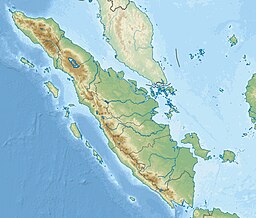
Lake Kerinci (Indonesian: Danau Kerinci) is a lake in Jambi, Indonesia. It is located at 2°8′55″S 101°29′34″E / 2.14861°S 101.49278°E / -2.14861; 101.49278.
The cyprinid fish Osteochilus kerinciensis is named after Lake Kerinci, its type locality.
See also
References
- ^ Tan, Heok Hui & Maurice Kottelat (2009). "The fishes of the Batang Hari drainage, Sumatra, with description of six new species" (PDF). Ichthyological Exploration of Freshwaters. 20 (1): 13–69. hdl:10635/101912.
- Nakano, Shin-ichi; Yahara, Tetsukazu; Nakashizuka, Tohru, eds. (2016). Aquatic Biodiversity Conservation and Ecosystem Services. Springer. p. 7. ISBN 9811007802.
This Jambi location article is a stub. You can help Misplaced Pages by expanding it. |