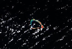
 NASA false-color photograph of Lae Atoll NASA false-color photograph of Lae Atoll | |
 | |
 | |
| Geography | |
|---|---|
| Location | North Pacific |
| Coordinates | 08°56′10″N 166°14′15″E / 8.93611°N 166.23750°E / 8.93611; 166.23750 |
| Archipelago | Ralik |
| Total islands | 20 |
| Area | 1.5 km (0.58 sq mi) |
| Highest elevation | 3 m (10 ft) |
| Administration | |
| Demographics | |
| Population | 133 (2021) |
| Ethnic groups | Marshallese |
Lae Atoll (Marshallese: Lae, ) is a coral atoll of 20 islands in the Pacific Ocean, and forms a legislative district of the Ralik Chain of the Marshall Islands. Its total land area is only 1.5 square kilometers (0.58 sq mi), but it encloses a lagoon with an area of 17.7 square kilometers (6.8 sq mi). It is located approximately 47 kilometers (29 mi) east of Ujae Atoll. The population of Lae Atoll was 133 in 2021. Its islands include Lae, Looj (Lotj), Bilalalon, Riblong (Ribon) and Lweijab (Lejab).
History
In early 1884, Japanese explorer and agent Suzuki Tsunenori was dispatched to Lae Atoll to investigate the murder of a Japanese sailor. When he arrived, he raised the national flag and claimed the island for Japan. However, he was ordered to return to the island to take down the flag, and the government made no formal gestures towards annexation of the islands. Lae Atoll was claimed by the German Empire along with the rest of the Marshall Islands in 1885. After World War I, the island came under the South Seas Mandate of the Empire of Japan. Following the end of World War II, Lae came under the control of the United States as part of the Trust Territory of the Pacific Islands. It has been part of the independent Republic of the Marshall Islands since 1986.
Education
Marshall Islands Public School System operates Lae Elementary School.
Kwajalein Atoll High School on Kwajalein serves the community.
References
- Marshallese-English Dictionary - Place Name Index
- "Republic of the Marshall Islands 2021 Census Report, Volume 1: Basic Tables and Administrative Report" (PDF). Pacific Community (SPC): Statistics for Development Division. Pacific Community. May 30, 2023. Archived from the original (PDF) on 2023-09-27. Retrieved September 27, 2023.
- Schuler, Friedrich (2015). Secret Wars and Secret Policies in the Americas, 1842-1929. University of New Mexico Press. ISBN 9780826344908.
- Churchill, William (1920). "Germany's Lost Pacific Empire". Geographical Review. 10 (2): 84–90. Bibcode:1920GeoRv..10...84C. doi:10.2307/207706. JSTOR 207706.
- "Public Schools Archived 2018-02-21 at the Wayback Machine." Marshall Islands Public School System. Retrieved on February 21, 2018.
- "Annual Report 2011-2012 Archived 2018-02-22 at the Wayback Machine." Ministry of Education (Marshall Islands). Retrieved on February 22, 2018. p. 54 (PDF p. 55/118). "Kwajalein Atoll High School enrolls students from Kwajalein and the Kabinmeto zone including schools in Ujae, Lae, and Wotto."
External links
- Marshall Islands site
- Entry at Oceandots.com at the Wayback Machine (archived December 23, 2010)
| Marshall Islands articles | |||||||
|---|---|---|---|---|---|---|---|
| History | |||||||
| Geography |
| ||||||
| Politics |
| ||||||
| Economy | |||||||
| Culture |
| ||||||
| |||||||
This Marshall Islands location article is a stub. You can help Misplaced Pages by expanding it. |