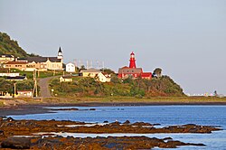
Municipality in Quebec, Canada
| La Martre | |
|---|---|
| Municipality | |
 La Martre Lighthouse La Martre Lighthouse | |
 Location within La Haute-Gaspésie RCM Location within La Haute-Gaspésie RCM | |
 | |
| Coordinates: 49°10′N 66°10′W / 49.167°N 66.167°W / 49.167; -66.167 | |
| Country | Canada |
| Province | Quebec |
| Region | Gaspésie–Îles-de-la-Madeleine |
| RCM | La Haute-Gaspésie |
| Constituted | December 18, 1923 |
| Government | |
| • Mayor | Yves Sohier |
| • Federal riding | Haute-Gaspésie—La Mitis—Matane—Matapédia |
| • Prov. riding | Gaspé |
| Area | |
| • Total | 179.11 km (69.15 sq mi) |
| • Land | 175.23 km (67.66 sq mi) |
| Population | |
| • Total | 194 |
| • Density | 1.1/km (3/sq mi) |
| • Pop (2016-21) | |
| • Dwellings | 119 |
| Time zone | UTC−5 (EST) |
| • Summer (DST) | UTC−4 (EDT) |
| Postal code(s) | G0E 2H0 |
| Area code(s) | 418 and 581 |
| Highways | |
| Website | www |
La Martre (French pronunciation: [la maʁtʁ]) is a municipality in the Gaspésie-Îles-de-la-Madeleine region of the province of Quebec in Canada.
In addition to La Martre itself, the municipality also includes the communities of Cap-au-Renard, Christie, and Sainte-Marthe-de-Gaspé.
History

The area saw permanent settlement in the late 19th century and was originally called Rivière-à-la-Marthe, after the Marten River (French: Rivière à la Marthe) that flows into the Gulf of Saint Lawrence there. The marten is found along this river's banks and is abundant in the Gaspé region.
In 1923, the place separated from the municipality of Sainte-Anne-des-Monts to form the Township Municipality of Christie, named in honour of Robert Christie. In 1950, the township municipality was split in two when Marsoui was incorporated as a village municipality.
In 1970, the municipality was renamed to La Martre.
Demographics

In the 2021 Census of Population conducted by Statistics Canada, La Martre had a population of 194 living in 84 of its 119 total private dwellings, a change of -20.2% from its 2016 population of 243. With a land area of 175.23 km (67.66 sq mi), it had a population density of 1.1/km (2.9/sq mi) in 2021.
Canada census – La Martre community profile| 2021 | 2016 | 2011 | |
|---|---|---|---|
| Population | 194 (-20.2% from 2016) | 243 (-0.8% from 2011) | 245 (-3.2% from 2006) |
| Land area | 175.23 km (67.66 sq mi) | 175.46 km (67.75 sq mi) | 173.24 km (66.89 sq mi) |
| Population density | 1.1/km (2.8/sq mi) | 1.4/km (3.6/sq mi) | 1.4/km (3.6/sq mi) |
| Median age | 55.2 (M: 57.2, F: 48.0) | 52.1 (M: 51.8, F: 53.0) | 50.2 (M: 50.2, F: 50.2) |
| Private dwellings | 119 (total) 84 (occupied) | 147 (total) 99 (occupied) | 184 (total) |
| Median household income | $.N/A | $45,184 | $.N/A |
References: 2021 2016 2011
|
|
| ||||||||||||||||||||||||||||||||||||||||||||||||||||||||||||
| Population counts are not adjusted for boundary changes. Source: Statistics Canada | ||||||||||||||||||||||||||||||||||||||||||||||||||||||||||||||
Government
List of former mayors:
- Louis Roy (1924–1926)
- Pierre Maloney (1926–1937)
- Roger L'Italien (1937–1939, 1949–1953)
- Willie Gagnon (1939–1945, 1947–1949)
- Marcellin Campion (1945–1947)
- Gérard Gagnon (1953–1957, 1958–1959)
- Damase Morin (1957–1958)
- Maurice Gasse (1959–1965)
- Grégoire Gasse (1965–1971)
- Jean-Yves Gagnon (1971–1973, 1980–1989)
- Ovilla Vallée (1973–1976, 1977–1980)
- Noël Vallée (1976–1977)
- Albert Robinson (1980)
- Jean-Guy Vallée (1989–1990)
- Fernand Hanley (1990–1992)
- Raymond St-Pierre (1992–1996, 2005–2009)
- Théodule Dion (1996–1999)
- Harold Gagnon (1999–2005)
- Claudette Robinson (2009–2013)
- Michel Laperle (2013–2014)
- Yves Sohier (2014–present)
Gallery
See also
References
- ^ "La Martre (Municipalité)" (in French). Commission de toponymie du Québec. Retrieved 2011-12-19.
- ^ "Répertoire des municipalités: Geographic code 04030". www.mamh.gouv.qc.ca (in French). Ministère des Affaires municipales et de l'Habitation. Retrieved 2024-08-12.
- ^ "La Martre, Quebec (Code 2404030) Census Profile". 2021 census. Government of Canada - Statistics Canada. Retrieved 2024-08-12.
- "Toponyms". Le directeur général des élections du Québec (Quebec election office). 24 August 2009. Retrieved 2010-03-11.
- "Municipalité, historique" (in French). Municipalité de Marsoui. Retrieved 2011-12-16.
- "Population and dwelling counts: Canada, provinces and territories, and census subdivisions (municipalities), Quebec". Statistics Canada. February 9, 2022. Retrieved October 4, 2024.
- "2021 Community Profiles". 2021 Canadian census. Statistics Canada. February 4, 2022. Retrieved 2023-10-19.
- "2016 Community Profiles". 2016 Canadian census. Statistics Canada. August 12, 2021. Retrieved 2022-07-14.
- "2011 Community Profiles". 2011 Canadian census. Statistics Canada. March 21, 2019. Retrieved 2013-05-14.
- "1971 Census of Canada - Population Census Subdivisions (Historical)". Catalogue 92-702 Vol I, part 1 (Bulletin 1.1-2). Statistics Canada: 76, 139. July 1973.
- 1996, 2001, 2006, 2011, 2016, 2021 census
- "Répertoire des entités géopolitiques: La Martre (municipalité) 18.12.1923 - ..." www.mairesduquebec.com. Institut généalogique Drouin. Retrieved 12 August 2024.
External links
| Adjacent Municipal Subdivisions | ||||||||||||||||
|---|---|---|---|---|---|---|---|---|---|---|---|---|---|---|---|---|
| ||||||||||||||||
| Cities | |
|---|---|
| Municipalities | |
| Villages | |
| Unorganized territories | |
| |
