| This article needs additional citations for verification. Please help improve this article by adding citations to reliable sources. Unsourced material may be challenged and removed. Find sources: "Kruopinė Hill" – news · newspapers · books · scholar · JSTOR (October 2023) (Learn how and when to remove this message) |

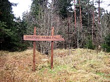
Kruopinė (Žybartonys) Hill is a hill near Vilnius which is the second highest point in Lithuania. Its elevation is 293.65 metres.
It was formerly believed to be highest point in Lithuania. However, in 2007 the peaks were remeasured by staff at Vilnius Gediminas Technical University, using GPS technology. The status of highest elevation in Lithuania is now considered to be Aukštojas Hill, at 293.84 metres, approximately 10km away.
See also
- Aukštojas Hill, the actual highest point in Lithuania
- Juozapinė Hill, also formerly stated to be the highest point
References
- Krupick, Rimantas. "Kurios kalvos Lietuvoje aukščiausios?". Lietuvos Geografijos Mokytoju Asociacija. Archived from the original on 30 September 2007.
- Post Report: Lithuania. U.S. Department of State. 1997. p. 1. Retrieved 15 October 2023.
External links
54°32′N 25°29′E / 54.533°N 25.483°E / 54.533; 25.483
This Vilnius County, Lithuania location article is a stub. You can help Misplaced Pages by expanding it. |