| Kau Nga Ling | |
|---|---|
| 狗牙嶺 | |
 Kau Nga Ling Ridge Kau Nga Ling Ridge | |
| Highest point | |
| Elevation | 539 m (1,768 ft) |
| Prominence | 539 m (1,768 ft) |
| Coordinates | 22°14′17″N 113°55′05″E / 22.238°N 113.918°E / 22.238; 113.918 |
| Geography | |
 | |
| Location | Lantau Island, |
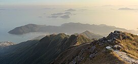
Kau Nga Ling (Chinese: 狗牙嶺; lit. 'Dog Teeth Range'), is a series of precipitous mountains on Lantau Island, Hong Kong, with a height of 539 metres (1,768 ft) above sea level. It is one of 16 "high-risk" hiking locations identified by the local government. Kau Nga Ling is inside Lantau South Country Park, which was created in 1978.

Name
The mountains resemble the teeth of dogs, when viewed from above.
Geology

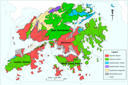
Volcanic rocks are widely distributed in Hong Kong and formed most of the highest mountains in Hong Kong, such as Tai Mo Shan (957 m, the highest mountain), Lantau Peak (934 m, the second highest mountain) and surrounding mountains including Kau Nga Ling. This is in contrast to the many mountains in the Kowloon area that are formed by Granitic rocks, such as Lion Rock.
Geography
To the north of Kau Nga Ling is Lantau Peak's summit (934 metres (3,064 ft)). To the west is Shek Pik Reservoir, which captures water from Kau Nga Ling and nearby ridges. To the south is the Tong Fuk village area, while to the east is Cheung Yan Shan (443 metres (1,453 ft)).
Access

There are three primary ridge hikes on Kau Nga Ling -- West Kau Nga, Middle Kau Nga and East Kau Nga. All three routes are technically and physically demanding, as hikers need to deal with jagged clusters of rocks under exposed conditions.
Among the three routes going up, West Kau Nga is considered the most difficult to climb, and it meets Middle Kau Nga at a precarious location called Lifeline (一線生機), where only one person could go through at any given time.
West Dog's Teeth Hike
Often referred to as one of the toughest trails in Hong Kong, the West Dog's Teeth hike is a demanding route that should only be attempted by experienced hikers. It is not an official trail and requires scrambling up steep, rocky surfaces using both hands and feet for support. The hike begins from Shek Pik Reservoir, which can be reached by bus from Tung Chung.
The recommended route is to continue up to Lantau Peak (Hong Kong's 2nd tallest mountain) from West Dog's Teeth, though it is also possible to head down to the Ngong Ping Big Buddha instead.
After reaching Lantau Peak, there is an official trail heading all the way down to Pak Kung Au, where buses are available to various parts of Lantau Island.
Hiking safety
Kau Nga Ling is one of the most demanding and dangerous hiking spots for experienced hikers in Hong Kong.
Many hikers have perished or suffered serious injuries on Kau Nga Ling, so precautions are necessary.
See also
References
- "PRIMARY, SECONDARY & TERTIARY PLANNING UNIT AND VILLAGE CLUSTER BOUNDARIES SHEK PIK, SOKO ISLANDS, CHI MA WAN PENINSULA AND CHEUNG CHAU 2016 POPULATION BY-CENS" (PDF). Hong Kong Government Planning Department.
- "Hiker dies from a 30-metre fall at Kau Nga Ling on Lantau Island". Young Post | South China Morning Post. Retrieved 2020-03-31.
- "WSD - Shek Pik Reservoir". www.wsd.gov.hk. Retrieved 2020-03-31.
- "West Dogs Tooth". Hong Kong Hikers. Retrieved 2020-03-31.
- says, Kim R. Comilang (2020-01-15). "WEST DOG'S TEETH HIKE 'HARDEST HIKE IN HONG KONG'". Journey Era. Retrieved 2020-03-31.
- ^ "West Dog's Teeth Hike: A Tough Climb Up One of Hong Kong's Steepest Ridges". Hong Kong Hike. Retrieved 2025-01-10.
- staff, Asia Times (2017-11-27). "Hiker, 69, falls to death on notorious Lantau Island trail". Asia Times. Retrieved 2020-03-31.
- CoconutsHongKong (2018-10-29). "Woman discharged from hospital after slipping on Dog Teeth Range | Coconuts Hong Kong". Coconuts. Retrieved 2020-03-31.
- "行山男狗牙嶺「一線生機」墮崖亡". on.cc東網 (in Chinese (Hong Kong)). Retrieved 2020-03-31.
This article related to a mountain or hill in Hong Kong is a stub. You can help Misplaced Pages by expanding it. |