| Katonkaragay | |
|---|---|
| District | |
| Катонқарағай ауданы Катон-Карагайский район | |
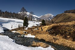
 Kara-Koba River, Markakol Nature Reserve Kara-Koba River, Markakol Nature Reserve | |
 Coat of arms Coat of arms | |
 | |
 | |
| Coordinates: 49°12′41″N 84°30′50″E / 49.2113°N 84.5138°E / 49.2113; 84.5138 | |
| Country | |
| Region | East Kazakhstan Region |
| Administrative center | Katonkaragay |
| Founded | 1928 |
| Government | |
| • Akim | Calican Dildar Kalikanovich |
| Area | |
| • Total | 13,167 km (5,084 sq mi) |
| Population | |
| • Total | 28,008 |
| Time zone | UTC+6 (East) |
| Saka kurgans | ||||||||||||||||||||||||||||||
|---|---|---|---|---|---|---|---|---|---|---|---|---|---|---|---|---|---|---|---|---|---|---|---|---|---|---|---|---|---|---|
 | ||||||||||||||||||||||||||||||
|
||||||||||||||||||||||||||||||
Katonkaragay, also spelled Katon-Karagay (Kazakh: Қатонқарағай ауданы, romanized: Qatonqarağai audany) is a district of East Kazakhstan Region in eastern Kazakhstan. The administrative center of the district is the selo of Katonkaragay. It is the easternmost district in Kazakhstan. Population: 28,008 (2013 estimate); 30,056 (2009 Census results); 45,149 (1999 Census results).
Berel burial mound
Main article: Berel, KazakhstanNear the selo of Berel (49°22′24″N 86°26′17″E / 49.3732082°N 86.4380264°E / 49.3732082; 86.4380264 (Berel)) excavations of ancient burial mounds have revealed artefacts the sophistication of which are encouraging a revaluation of the nomadic cultures of the 3rd and 4th centuries BC.
References
- "Акимат Катон-Карагайского района". www.gov.kz.
- ^ "Население Республики Казахстан" (in Russian). Департамент социальной и демографической статистики. Retrieved 27 December 2013.
- Image file with complete data, Amir, Saltanat; Roberts, Rebecca C. (2023). "The Saka 'Animal Style' in Context: Material, Technology, Form and Use". Arts. 12: 23. doi:10.3390/arts12010023.
- "Subdivisions of Kazakhstan in local languages". Geonames.de. Archived from the original on 2016-03-03. Retrieved 2014-02-28.
- ^ "Население Республики Казахстан" [Population of the Republic of Kazakhstan] (in Russian). Департамент социальной и демографической статистики. Retrieved 8 December 2013.
- Archived June 23, 2007, at the Wayback Machine
- Wilford, John Noble (12 March 2012). "Artifacts Show Sophistication of Ancient Nomads". The New York Times. Retrieved 2014-03-01.
External links
| East Kazakhstan Region | ||
|---|---|---|
| Capital: Oskemen | ||
| Districts |  | |
| Major cities | ||
This Kazakhstan location article is a stub. You can help Misplaced Pages by expanding it. |