| Karlshagen | |
|---|---|
| Municipality | |
 Houses with typical thatched roofs in Karlshagen (Reed houses) Houses with typical thatched roofs in Karlshagen (Reed houses) | |
 Flag Flag Coat of arms Coat of arms | |
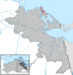
Location of Karlshagen within Vorpommern-Greifswald district
 | |
  | |
| Coordinates: 54°07′N 13°49′E / 54.117°N 13.817°E / 54.117; 13.817 | |
| Country | Germany |
| State | Mecklenburg-Vorpommern |
| District | Vorpommern-Greifswald |
| Municipal assoc. | Usedom-Nord |
| Government | |
| • Mayor | Christian Höhn |
| Area | |
| • Total | 5.07 km (1.96 sq mi) |
| Elevation | 3 m (10 ft) |
| Population | |
| • Total | 3,191 |
| • Density | 630/km (1,600/sq mi) |
| Time zone | UTC+01:00 (CET) |
| • Summer (DST) | UTC+02:00 (CEST) |
| Postal codes | 17449 |
| Dialling codes | 038371 |
| Vehicle registration | VG |
| Website | www.karlshagen.de |
Karlshagen is a Baltic Sea resort in Western Pomerania in the north of the island Usedom. Karlshagen has 3400 inhabitants and lies between Zinnowitz and Peenemünde.
In 1885, a pier was developed in Karlshagen. Today it is the most important yachting port of Usedom. Between 1939 and 1945, Karlshagen lay in the restricted area of the army laboratory Peenemünde Army Research Center.
Karlshagen also was the location of the housing development for high-level personnel and scientists working in the nearby laboratory. Although the buildings were largely destroyed in the air raids of 1943/44, some parts are preserved. From 1949 to 1989, Karlshagen belonged to the German Democratic Republic. During this period, the area north of Karlshagen, including the village Peenemuende, was a restricted-access area.
The 75-metre-high pylons of a three-phase 110 kV alternating current overhead line running between Peenemuende and Karlshagen are visible for a considerable distance. This line was built in the early 1950s, in order to transport the electrical power generated on the island to the mainland, as it was no longer needed in Usedom after the laboratory was shut down. Later, a branch line was established to the transformer station in Karlshagen. After the Peenemuende power plant was shut down in 1990, the branch of the overhead line to the plant was dismantled, so now only the Karlshagen transformer station is fed by the line running across the Peene.
References
- "Bevölkerungsstand der Kreise, Ämter und Gemeinden 2023" (XLS) (in German). Statistisches Amt Mecklenburg-Vorpommern. 2023.
External links
![]() Media related to Karlshagen at Wikimedia Commons
Media related to Karlshagen at Wikimedia Commons
- Official website of Ostseebad Karlshagen (German)
- Pylons for the High-Voltage Peene Crossing at Karlshagen at Structurae
This Vorpommern-Greifswald location article is a stub. You can help Misplaced Pages by expanding it. |