| This article does not cite any sources. Please help improve this article by adding citations to reliable sources. Unsourced material may be challenged and removed. Find sources: "Kanmon Bridge" – news · newspapers · books · scholar · JSTOR (April 2019) (Learn how and when to remove this message) |


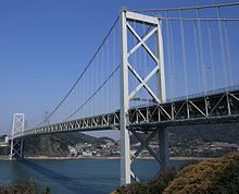
The Kanmon Bridge (関門橋, Kanmonkyō) (Asian Highway Network ![]() AH1) is a suspension bridge crossing the Kanmon Straits, a stretch of water separating two of Japan's four main islands. On the Honshū side of the bridge is Shimonoseki (下関, which contributed Kan to the name of the strait) and on the Kyūshū side is Kitakyushu, whose former city and present ward, Moji (門司), gave the strait its mon.
AH1) is a suspension bridge crossing the Kanmon Straits, a stretch of water separating two of Japan's four main islands. On the Honshū side of the bridge is Shimonoseki (下関, which contributed Kan to the name of the strait) and on the Kyūshū side is Kitakyushu, whose former city and present ward, Moji (門司), gave the strait its mon.
The Kanmon Bridge was opened to vehicles on November 14, 1973 and connected to the Kyūshū Expressway on March 27, 1984. It is among the 50 largest suspension bridges in the world with a central length of 1,068 metres (3,504 feet).
See also
External links
33°57′43″N 130°57′30″E / 33.96194°N 130.95833°E / 33.96194; 130.95833
This article about a bridge in Japan is a stub. You can help Misplaced Pages by expanding it. |