New York City Subway station in Brooklyn, New York
| Jefferson Street | |||||||||||||||||||||||||||||||||||||||||||||||||||||||||||||
|---|---|---|---|---|---|---|---|---|---|---|---|---|---|---|---|---|---|---|---|---|---|---|---|---|---|---|---|---|---|---|---|---|---|---|---|---|---|---|---|---|---|---|---|---|---|---|---|---|---|---|---|---|---|---|---|---|---|---|---|---|---|
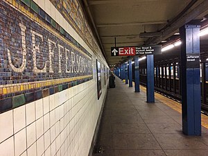
 Northbound platform Northbound platform | |||||||||||||||||||||||||||||||||||||||||||||||||||||||||||||
| Station statistics | |||||||||||||||||||||||||||||||||||||||||||||||||||||||||||||
| Address | Jefferson Street & Wyckoff Avenue Brooklyn, New York | ||||||||||||||||||||||||||||||||||||||||||||||||||||||||||||
| Borough | Brooklyn | ||||||||||||||||||||||||||||||||||||||||||||||||||||||||||||
| Locale | Bushwick | ||||||||||||||||||||||||||||||||||||||||||||||||||||||||||||
| Coordinates | 40°42′25″N 73°55′25″W / 40.706994°N 73.923569°W / 40.706994; -73.923569 | ||||||||||||||||||||||||||||||||||||||||||||||||||||||||||||
| Division | B (BMT) | ||||||||||||||||||||||||||||||||||||||||||||||||||||||||||||
| Line | BMT Canarsie Line | ||||||||||||||||||||||||||||||||||||||||||||||||||||||||||||
| Services | L (all times) | ||||||||||||||||||||||||||||||||||||||||||||||||||||||||||||
| Transit | |||||||||||||||||||||||||||||||||||||||||||||||||||||||||||||
| Structure | Underground | ||||||||||||||||||||||||||||||||||||||||||||||||||||||||||||
| Platforms | 2 side platforms | ||||||||||||||||||||||||||||||||||||||||||||||||||||||||||||
| Tracks | 2 | ||||||||||||||||||||||||||||||||||||||||||||||||||||||||||||
| Other information | |||||||||||||||||||||||||||||||||||||||||||||||||||||||||||||
| Opened | July 14, 1928; 96 years ago (1928-07-14) | ||||||||||||||||||||||||||||||||||||||||||||||||||||||||||||
| Accessible | not ADA-accessible; accessibility planned | ||||||||||||||||||||||||||||||||||||||||||||||||||||||||||||
| Opposite- direction transfer | Yes | ||||||||||||||||||||||||||||||||||||||||||||||||||||||||||||
| Traffic | |||||||||||||||||||||||||||||||||||||||||||||||||||||||||||||
| 2023 | 2,075,924 | ||||||||||||||||||||||||||||||||||||||||||||||||||||||||||||
| Rank | 163 out of 423 | ||||||||||||||||||||||||||||||||||||||||||||||||||||||||||||
| |||||||||||||||||||||||||||||||||||||||||||||||||||||||||||||
| |||||||||||||||||||||||||||||||||||||||||||||||||||||||||||||
| |||||||||||||||||||||||||||||||||||||||||||||||||||||||||||||
| |||||||||||||||||||||||||||||||||||||||||||||||||||||||||||||
| |||||||||||||||||||||||||||||||||||||||||||||||||||||||||||||
The Jefferson Street station is a station on the BMT Canarsie Line of the New York City Subway. Located in Bushwick, Brooklyn at the intersection of Jefferson Street and Wyckoff Avenue, it is served by the L train at all times.
History
Background

In 1913, the Dual Contracts were signed, which called for the construction of various rapid transit services throughout the City of New York. Among these was a subway line initially known as the 14th Street–Eastern District Line, usually shortened to 14th Street–Eastern Line. The line would run beneath 14th Street in Manhattan, from Sixth Avenue under the East River and through Williamsburg to Montrose and Bushwick Avenues in Brooklyn. Booth and Flinn was awarded the contract to construct the line on January 13, 1916. Clifford Milburn Holland served as the engineer-in-charge during the construction.
Due to the city's failure to approve the section of the line between Montrose Avenue and East New York, the 14th Street/Eastern Line was initially isolated from the rest of the system. In 1924, a temporary connection was built from the Long Island Rail Road (LIRR)'s Bushwick Yard that ran via Montrose Avenue and then connected to the 14th Street/Eastern Line under Bushwick Avenue just near the Montrose Avenue station. This was done to allow the delivery of BMT Standard subway cars. The first of the cars were delivered by this ramp on June 20, 1924. On June 30, 1924, the section between Sixth Avenue in Manhattan and Montrose Avenue in Brooklyn opened.
Construction and opening
For the extension of the 14th Street/Eastern Line from Montrose Avenue to East New York, the New York City Board of Estimate had initially given its consent to an elevated line over the Evergreen Branch of the LIRR. The Board of Estimate subsequently refused to allow a construction contract for the elevated line, while the BRT did not want to build an underground line. The extension was changed to an underground alignment following opposition from industries on the Evergreen Branch. In July 1924, the New York City Board of Transportation (BOT) approved a modified route for recommendation to the Board of Estimate. The route would be wholly underground and consist of three tracks. From Montrose Avenue, it would curve east under McKibbin Street, private property, and Harrison Place. Past Varick Avenue, it would turn southeast to Wyckoff Avenue, underneath which it would run to Eldert Street. This plan was to cost $8 million.
In September 1924, the BOT approved the remaining section of the route between Eldert Street and Broadway Junction in East New York. East of Eldert Street, the route would turn south to a ground-level alignment parallel to the LIRR's Bay Ridge Branch, then run southeast in a tunnel underneath private property to the intersection of Eastern Parkway and Bushwick Avenue, where it would emerge onto a ramp leading to the existing Canarsie elevated. An ornamental viaduct over Bushwick Avenue and Eastern Parkway was removed from the original plans due to opposition from property owners.
Three contracts for the construction of the extension were awarded in December at a total cost of $9,531,204. The section from Montrose Avenue to Varick Avenue was awarded to the Underpinning and Foundation Company, while the section from Varick Avenue to Bleecker Street and from Bleecker Street to Halsey Street went to the Oakdale Contracting Company.
On July 14, 1928, the line was extended further east beneath Wyckoff Avenue and then south paralleling the Bay Ridge Branch to a new station at Broadway Junction, above the existing station on the Broadway Elevated (Jamaica Line). At this time, it was connected to the already-operating elevated line to Canarsie. The Jefferson Street station opened as part of this extension.
Station renovation
In 2019, the Metropolitan Transportation Authority announced that this station would become ADA-accessible as part of the agency's 2020–2024 Capital Program. The project was to be funded by congestion pricing in New York City, but it was postponed in June 2024 after the implementation of congestion pricing was delayed.
Station layout


| Ground | Street level | Exit/entrance |
| Mezzanine | Mezzanine | Fare control, station agent, MetroCard machines |
| Platform level | Side platform | |
| Westbound | ← | |
| Eastbound | → | |
| Side platform | ||
This underground station has two side platforms and two tracks. The northbound platform is 535 feet (163 m) long, while the southbound platform is 537 feet (164 m) long, and both platforms are 12 feet (3.7 m) wide.
The mosaic tile bands on both platforms are predominantly blue and brown with yellow and tan accents. There is a full frieze of icons with correct details. The colors, however, shift from the earth tones found in the original design to more pastel shades of rose, slate blue, yellow and peach. Some of the background tile is mottled. This is handmade work with all of the proper elements, including randomly cut and set tiles in the center. "J" tablets on a blue background run along the trim line at regular intervals.
The station's name tablets read "JEFFERSON ST." in gold serif lettering on a blue/dark red background, yellow inner border, and green outer border. There are also directional signs in gold serif lettering on blue/dark red background and yellow/green border. Blue i-beam columns run along both platforms at regular intervals with alternating ones having the standard black station name plate in white lettering. New tile was installed at the Canarsie-bound platform in the summer of 2000.
Exits
This station's full-time fare control area is at the extreme east (railroad south) end. A double-width staircase from each platform goes up to a waiting area/crossover, where a turnstile provides entrance/exit from the station. Outside fare control, there is a token booth and four staircases going up to all corners of Starr Street and Wyckoff Avenue.
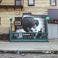
Both platforms have a same-level, unstaffed fare control area at the opposite end. One exit-only turnstile and one High Entry/Exit Turnstile lead to an enclosed staircase going up to a small brick building on either western corners of Jefferson Street and Wyckoff Avenue. The Manhattan-bound building is on the northwest corner while the Canarsie-bound building is on the southwest one.
References
- "Glossary". Second Avenue Subway Supplemental Draft Environmental Impact Statement (SDEIS) (PDF). Vol. 1. Metropolitan Transportation Authority. March 4, 2003. pp. 1–2. Archived from the original (PDF) on February 26, 2021. Retrieved January 1, 2021.
- ^ "Annual Subway Ridership (2018–2023)". Metropolitan Transportation Authority. 2023. Retrieved April 20, 2024.
- "Official Map of Dual Subway Showing Lines and Stations". The New York Times. April 26, 1914. ISSN 0362-4331. Retrieved June 11, 2021.
- "East River Tunnel Contract Awarded". The New York Times. January 14, 1916. Retrieved February 28, 2010.
- Aronson, Michael (June 15, 1999). "The Digger Clifford Holland". Daily News. New York. Archived from the original on July 5, 2017. Retrieved July 2, 2010.
- "Installing Cars in 14th St. E. D. Subway". The Chat. June 21, 1924. p. 1. Retrieved June 11, 2021.
- "Subway Tunnel Through". The New York Times. August 8, 1919. Retrieved February 28, 2010.
- "Celebrate Opening of Subway Link". The New York Times. July 1, 1924. Retrieved February 13, 2010.
- "Long Delayed E. D. Transit Relief Move Announced". The Standard Union. October 29, 1922. pp. 9, 11. Retrieved June 11, 2021.
- "New Link Approved by Subway Board; Extension of Eastern District Line Corresponds to Mayor's Program" (PDF). The New York Times. July 16, 1924. p. 19. ISSN 0362-4331. Retrieved June 11, 2021.
- "Fix Rest of Route of 14th St. Subway; Transportation Board Agrees on Line to the Elevated at Broadway, Brooklyn". The New York Times. September 24, 1924. ISSN 0362-4331. Retrieved June 11, 2021.
- "Viaduct Plan for Tube Vigorously Denounced". The Chat. August 9, 1924. p. 29. Retrieved June 11, 2021.
- "3 Contracts Awarded for 14th St. Subway; Aggregate $9,531,204 and Call for Operation of Trains Within Twenty-eight Months". The New York Times. November 12, 1924. ISSN 0362-4331. Retrieved June 11, 2021.
- "Last Link of New 14th St-E.D. Subway To Be Opened Today: First Train This Afternoon Will Carry Officials – Citizens to Celebrate". Brooklyn Daily Eagle. July 14, 1928. Retrieved August 25, 2015.
- "CELEBRATE OPENING OF NEW B. M. T. LINE; Officials and Civic Association Members Fill First Train From Union Square. MET BY BAND AT CANARSIE Crowds Cheer Passing Cars at Stations Along New Route to Jamaica Bay". The New York Times. July 15, 1928. ISSN 0362-4331. Retrieved January 1, 2018.
- "Districts Unite To Hail Opening Of Subway Link: Delegations All Way to Canarsie Welcome First Train, That Is Flag-Draped Many Officials on Board Lockwood in Speech Promises Better Connections". New York Herald Tribune. July 15, 1928. p. 17. ProQuest 1113768361.
- "Press Release - MTA Headquarters - MTA Announces 20 Additional Subway Stations to Receive Accessibility Improvements Under Proposed 2020-2024 Capital Plan". MTA. December 19, 2019. Archived from the original on March 22, 2020. Retrieved December 25, 2019.
- Collins, Keith (July 11, 2024). "See How Your Subway Service May Suffer Without Congestion Pricing". The New York Times. ISSN 0362-4331. Retrieved July 12, 2024.
- "Stantec Station ADA Accessibility Analysis 2017 Jefferson Street". New York City Transit. December 31, 2019. Retrieved June 7, 2020.
- ^ "www.nycsubway.org".
- ^ "MTA Neighborhood Maps: Bushwick" (PDF). mta.info. Metropolitan Transportation Authority. 2015. Retrieved July 20, 2016.
External links
- Station Reporter — "L Train". stationreporter.net. Archived from the original on June 30, 2013.
- The Subway Nut — Jefferson Street Pictures
- Jefferson Street entrance from Google Maps Street View
- Starr Street entrance from Google Maps Street View
- Platforms from Google Maps Street View
| Stations of the New York City Subway, by service | |
|---|---|
Canarsie Local |
|
| |
| Stations of the New York City Subway, by line (physical trackage) | |
|---|---|
| Canarsie Line |
|
| |


