| Iton | |
|---|---|
 The Iton in Évreux The Iton in Évreux | |
 | |
| Location | |
| Country | France |
| Physical characteristics | |
| Source | |
| • location | Normandy |
| Mouth | |
| • location | Eure |
| • coordinates | 49°10′29″N 1°11′11″E / 49.17472°N 1.18639°E / 49.17472; 1.18639 |
| Length | 132 km (82 mi) |
| Basin size | 1,300 km (500 sq mi) |
| Basin features | |
| Progression | Eure→ Seine→ English Channel |
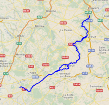
Iton (French pronunciation: [itɔ̃]) is a river in Normandy, France, left tributary of the river Eure. It is 131.8 km (81.9 mi) long. Its source is near Moulins-la-Marche. For about 10 km between Orvaux and Glisolles, it disappears and pursues a subterranean course.
The Iton flows through the following départements and towns:
It flows into the Eure in Acquigny, south of Louviers.
Its basin (1,300 km²) covers 134 communes and is subject to a schéma d'aménagement et de gestion des eaux (water management scheme).
References
External links
This Orne geographical article is a stub. You can help Misplaced Pages by expanding it. |
This Eure geographical article is a stub. You can help Misplaced Pages by expanding it. |
This article related to a river in France is a stub. You can help Misplaced Pages by expanding it. |