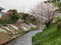
| Isehara 伊勢原市 | |
|---|---|
| City | |
 Isehara City Hall Isehara City Hall | |
 Flag Flag Seal Seal | |
 Location of Isehara in Kanagawa Prefecture Location of Isehara in Kanagawa Prefecture | |
 | |
| Coordinates: 35°23′N 139°18′E / 35.383°N 139.300°E / 35.383; 139.300 | |
| Country | Japan |
| Region | Kantō |
| Prefecture | Kanagawa |
| First official recorded | 655 BC (official) |
| Town settled | December 1,1954 |
| City settled | March 1, 1971 |
| Government | |
| • Mayor | Matsutaro Takayama (since October 2012) |
| Area | |
| • Total | 55.56 km (21.45 sq mi) |
| Population | |
| • Total | 101,415 |
| • Density | 1,800/km (4,700/sq mi) |
| Time zone | UTC+9 (Japan Standard Time) |
| City symbols | |
| • Tree | Castanopsis |
| • Flower | Chinese bellflower |
| • Bird | Copper pheasant |
| Phone number | 0463-94-4711 |
| Address | 348, Tanaka, Isehara-shi, Kanagawa-ken 259-1188 |
| Website | Official website |


Isehara (伊勢原市, Isehara-shi) is a city located in Kanagawa Prefecture, Japan. As of 1 February 2024, the city had an estimated population of 101,415 and a population density of 1800 persons per km. The total area of the city is 55.56 square kilometres (21.45 sq mi).
Geography
Isehara is located in the hilly center of Kanagawa Prefecture. A large portion of the city is within the Tanzawa-Ōyama Quasi-National Park.
Surrounding Municipalities
Kanagawa Prefecture
Climate
Isehara has a humid subtropical climate (Köppen Cfa) characterized by warm summers and cool winters with light to no snowfall. The average annual temperature in Isehara is 14.6 °C. The average annual rainfall is 1906 mm with September as the wettest month. The temperatures are highest on average in August, at around 24.2 °C, and lowest in January, at around 2.9 °C.
Demographics
Per Japanese census data, the population of Isehara has recently plateaued after several decades of strong growth.
| Year | Pop. | ±% |
|---|---|---|
| 1960 | 26,894 | — |
| 1970 | 43,751 | +62.7% |
| 1980 | 70,052 | +60.1% |
| 1990 | 89,567 | +27.9% |
| 2000 | 99,544 | +11.1% |
| 2010 | 101,039 | +1.5% |
| 2020 | 101,780 | +0.7% |
History
The area of present-day Isehara City was part of several large shōen in Sagami Province during the Kamakura period. During the Edo period, it was nominally part of Odawara Domain, although large portions were tenryō territory controlled by the shōgun in Edo through various hatamoto.
After the Meiji Restoration and with the establishment of the district system in 1878, the area came under the control of Ōsumi District (大住郡, Ōsumi-gun), Kanagawa Prefecture and became Isehara Town on April 1, 1889 with the establishment of the modern municipalities system. On March 26, 1896, Ōsumi District and Yurugi District were merged to create Naka District. The town began to experience rapid growth after the opening of Isehara Station on the Odakyu Electric Railway on April 1, 1929. On December 21, 1954, the town expanded through merger with neighboring Oyama Town and three villages. Its area expanded further on September 30, 1956, through annexation of a portion of neighboring Okazaki Village. Isehara was elevated to city status on March 1, 1971.
Government
Isehara has a mayor-council form of government with a directly elected mayor and a unicameral city council of 20 members. Isehara contributes one member to the Kanagawa Prefectural Assembly. In terms of national politics, the city is part of Kanagawa 16th district of the lower house of the Diet of Japan.
Economy
Known primarily as a bedroom community for Yokohama and the greater Tokyo area, Isehara is also home to Amada Co, a machine tool manufacturer and a number of manufacturing plants. It is also home to a Maru-Chan (Toyo Suisan) instant noodle factory.
Education
Isehara has ten public elementary schools and four public middle schools operated by the city government. The city has two public high schools operated by the Kanagawa Prefectural Board of Education, and the prefecture also operates one special education school for the handicapped. There is also one private high school. Tokyo-based Senshu University, Sanno University and Tokai University all have a campus within Isehara.
Transportation
Railway
![]() Odakyu Electric Railway – Odakyū Odawara Line
Odakyu Electric Railway – Odakyū Odawara Line
Highway
 National Route 246, to central Tokyo or Numazu
Sister cities
 Chino, Nagano, Japan, since January 21, 1986
 La Mirada, California, United States, since September 21, 1981
Local attractions
Notable people from Isehara
- Ōta Dōkan, Sengoku period warlord
- Yoshiyuki Kamei, politician
- Zentaro Kamei, politician
- Yasuhiro Kido, kickboxer
- Saeko Shimazu, voice actress
- Shinobu Yaguchi, film director and screenwriter
- Shiho Yoshimura, former volleyball player
References
- "Isehara city official statistics" (in Japanese). Japan.
- "Introduction of Isehara City" (in Japanese). Japan: Isehara City. Retrieved 6 May 2017.
- "Isehara climate: Temperature Isehara & Weather By Month". en.climate-data.org. Retrieved 2023-10-16.
- "Isehara (Kanagawa , Japan) - Population Statistics, Charts, Map, Location, Weather and Web Information". www.citypopulation.de. Retrieved 2023-10-16.
External links
- Official Website (in Japanese)
| Yokohama (capital) | ||||
| Yokohama |
| |||
| Kawasaki |
| |||
| Sagamihara |
| |||
| Core city | ||||
| Special cities | ||||
| Cities | ||||
| Districts | ||||