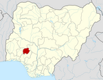
Place in Ekiti State, Nigeria
| Ikere-Ekiti | |
|---|---|
 | |
| Coordinates: 7°30′N 5°14′E / 7.500°N 5.233°E / 7.500; 5.233 | |
| Country | |
| State | Ekiti State |
| Government | |
| • Local Government Chairman and the Head of the Local Government Council | Hon (Sqn Ldr) Olu Adamolekun |
| • Asiwaju of Ikere-Land | Chief Wole Olanipekun, SAN. |
Ikere-Ekiti, also known as Ikere or Ikerre, is a city in Ekiti State of Nigeria. It is an agricultural and mine centre. According to the 1963 and 1991 census, the population was 114,780 and 60,257 respectively, but the 2006 census recorded it to be 147,355.
History
Oral tradition claims that a man by the name of Aladeselu, who is said to have originated from Uselu, a town close to Benin, created Ikere. Itinerant immigrants migrated from one location to another as it was customary in those days in quest of a suitable location to dwell.
Geography
Ikere LGA has a total size of 202 square kilometers and is distinguished by several hills, including the Orole and Olosunta hills. The area's average annual temperature is 27 degrees Celsius, and its total annual precipitation is estimated to be 1850 mm.
Economy
Ikere LGA is an agricultural area notable for the cultivation of a variety of crops including maize, okro, oil palm, yam, and cassava. The LGA also has a number of markets that offer venues for the trade of a variety of goods and services. Tailoring, blacksmithing, and the care and raising of domestic animals are additional significant economic activity in the Ikere LGA.
Climate
In Ikere-Ekiti, the dry season is hot, muggy, and partly cloudy whereas the wet season is warm, oppressive, and overcast. The temperature rarely drops below 58°F or rises over 95°F throughout the year, usually fluctuating between 64°F and 90°F.
From January 22 to March 30, the hot season, with an average daily high temperature exceeding 88°F, lasts for 2.2 months. Ikere-Ekiti experiences its hottest month of the year in March, with an average high of 88°F and low of 72°F.
From June 15 to October 12, the chilly season, which has an average daily high temperature below 82°F, lasts for 3.9 months. In Ikere-Ekiti, August is the coldest month of the year, with average lows of 69°F and highs of 81°F.
References
- "NigeianMuse.com". Retrieved 2007-04-05.
- United Nations estimate
- "The World Gazetteer". Archived from the original on 2013-02-10. Retrieved 2007-04-05.
- "About of Ikere-Ekiti - Google Search". www.google.com. Retrieved 2023-08-20.
- "Ikere-Ekiti | Traditional Culture, Festivals & Cuisine | Britannica". www.britannica.com. Retrieved 2023-08-20.
- "Ikere Local Government Area". www.manpower.com.ng. Retrieved 2023-08-20.
- "Ikere-Ekiti Climate, Weather By Month, Average Temperature (Nigeria) - Weather Spark". weatherspark.com. Retrieved 2023-08-20.
- "Ikere-Ekiti weather and climate ☀️ Best time to visit 🌡️ Temperature". www.besttravelmonths.com. Retrieved 2023-08-20.
- "Ikere-Ekiti Summer Weather, Average Temperature (Nigeria) - Weather Spark". weatherspark.com. Retrieved 2023-08-20.
- "Weather in Ikere-Ekiti, Ekiti State, Nigeria | Tomorrow.io". Tomorrow.io Weather. Retrieved 2023-08-20.
- "Simulated historical climate & weather data for Ikere-Ekiti". meteoblue. Retrieved 2023-08-20.
- "Ikere Annual Weather Averages". WorldWeatherOnline.com. Retrieved 2023-08-20.
7°30′N 5°14′E / 7.500°N 5.233°E / 7.500; 5.233
| State capital: Ado Ekiti | ||
| Local government areas |  | |
This Ekiti State, Nigeria location article is a stub. You can help Misplaced Pages by expanding it. |