You can help expand this article with text translated from the corresponding article in German. (October 2018) Click for important translation instructions.
|
| Ichte | |
|---|---|
 | |
| Location | |
| Country | Germany |
| States | Thuringia and Lower Saxony |
| Physical characteristics | |
| Source | |
| • location | East of the Oder Dam |
| • coordinates | 51°39′19″N 10°32′43″E / 51.6552°N 10.5453°E / 51.6552; 10.5453 |
| Mouth | |
| • location | northeast of Pützlingen, a district of Werther, into the Helme |
| • coordinates | 51°31′27″N 10°37′46″E / 51.5243°N 10.6295°E / 51.5243; 10.6295 |
| Basin features | |
| Progression | Helme→ Unstrut→ Saale→ Elbe→ North Sea |

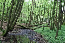
Ichte, in its upper course also called Steinaer Bach, is a river of Thuringia and Lower Saxony, Germany.
The Ichte springs east of the Oder Dam as Steinaer Bach in Lower Saxony. After the confluence of the Hellegrundbach, the river is called Ichte. The Ichte then crosses the boundary between Lower Saxony and Thuringia. It finally discharges northeast of Pützlingen [de; nl], a district of Werther, from the left into the Helme.
See also
References
- "Ichte (Steinaer Bach) source" (Map). Google Maps. Retrieved 28 October 2018.
- ^ "Hellegrundbach mouth" (Map). Google Maps. Retrieved 28 October 2018.
- "Ichte mouth" (Map). Google Maps. Retrieved 28 October 2018.
This article related to a river in Thuringia is a stub. You can help Misplaced Pages by expanding it. |
This article related to a river in Lower Saxony is a stub. You can help Misplaced Pages by expanding it. |