| Hunt Fjord | |
|---|---|
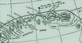
 Roosevelt Range section of Robert Peary's 1900 explorations map "Polar Regions". Roosevelt Range section of Robert Peary's 1900 explorations map "Polar Regions". | |
 | |
| Location | Arctic |
| Coordinates | 83°25′N 38°0′W / 83.417°N 38.000°W / 83.417; -38.000 |
| Ocean/sea sources | Lincoln Sea |
| Basin countries | Greenland |
| Max. length | 20 km (12 mi) |
| Max. width | 4.5 km (2.8 mi) |
| Frozen | All year round |
| Settlements | 0 |
Hunt Fjord is a fjord in Peary Land, northern Greenland. To the north the fjord has its mouth in the Lincoln Sea of the Arctic Ocean. Administratively it belongs to the Northeast Greenland National Park.
This fjord was named by Robert Peary in 1900.
Geography
Hunt Fjord opens to the Lincoln Sea to the east of Conger Sound and to the west of Benedict Fjord. It stretches in a southeast–northwest direction for about 20 km (12 mi).
Cape Kane is the headland on the western and Cape Washington on the eastern side of the mouth. On the western Roosevelt Land side the fjord is under the influence of slow-moving glaciers discharging on both sides of Cape Kane that completely fill it and partially clog neighboring Conger Sund as well. The large Thomas Glacier discharges at the head of Hunt Fjord from the western end of the Roosevelt Range. The Raven Glacier discharges on the eastern side, closer to the mouth, south of Cape Washington. The western shore of the fjord is glaciated with dark pointed nunataks protruding between short valleys filled with glaciers.
 |
Bibliography
- U.S. Geological Survey Professional Paper, Volume 1386, Part 3
See also
References
- ^ Geographical Items on North Greenland Encyclopedia Arctica 14
- "Hunt Fjord". Mapcarta. Retrieved 11 June 2019.
- GoogleEarth
- North Greenland Glacier Velocities and Calf Ice Production
- Prostar Sailing Directions 2005 Greenland and Iceland Enroute, p. 95
- R. E. Peary, Report of RE Peary, CE, USN, on Work Done in the Arctic in 1898-1902, 1903 - JSTOR
External links
This Greenland location article is a stub. You can help Misplaced Pages by expanding it. |