| This article needs additional citations for verification. Please help improve this article by adding citations to reliable sources. Unsourced material may be challenged and removed. Find sources: "Herzogstand" – news · newspapers · books · scholar · JSTOR (February 2016) (Learn how and when to remove this message) |
| Herzogstand | |
|---|---|
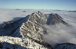
 Herzogstand from Heimgarten Herzogstand from Heimgarten | |
| Highest point | |
| Elevation | 1,731 m (5,679 ft) |
| Coordinates | 47°36′49.2″N 11°18′27.6″E / 47.613667°N 11.307667°E / 47.613667; 11.307667 |
| Geography | |
 | |
| Location | Bavaria, Germany |
| Parent range | Bavarian Prealps |
The Herzogstand is a mountain in the Bavarian foothills of the Alps, 75 kilometres (47 mi) south of the city of Munich. It has an elevation of 1,731 metres (5,679 ft) and is northwest of Lake Walchen. Maximilian II of Bavaria had a hunting lodge built underneath today's so-called Herzogstand-house in 1857. His successor, King Ludwig II, had a royal lodge built further up the mountain in 1865. The Herzogstand Cable Car renewed in 1994 following a fire in 1992, runs to Herzogstand-house at 1,575 metres (5,167 ft) above sea level, and then continues on to the summit of Farnkopf at 1,627 metres (5,338 ft).
The most popular ascent (AV way 446) leads from the valley station of the aerial tramway across the south side to Herzogstand-house and on to the summit of the mountain. An alternative descent leads along the somewhat exposed but well-secured ridge to the Heimgarten mountain (1,790 metres/5,870 ft), passing a lodge to the south of the Ohlstaedter Alm (1,423 metres/4,669 ft). The descent east of the Rotwandkopf continues down to the spa town of Walchensee (Kochel).
Transmitter
The summit of Herzogstand has been used since 1920 for radiotechnical purposes; a VLF transmission antenna was erected between 1920 and 1934. Today, an FM radio transmitter on Fahrenbergkopf broadcasts the following stations:
| Frequency | Program | ERP |
|---|---|---|
| 88.1 MHz | Bayern 1 (Reg. Obb.) | 0,1 kW |
| 91.0 MHz | Bayern 3 | 0,1 kW |
| 97.0 MHz | Bayern 2 (Reg. Obb.) | 0,1 kW |
| 99.9 MHz | Radio Alpenwelle | 0,1 kW |
| 102.0 MHz | Antenne Bayern | 0,1 kW |
| 104.1 MHz | 4 Klassik | 0,1 kW |
| 104.6 MHz | Radio Oberland | 0,1 kW |
| 106.7 MHz | B 5 aktuell | 0,1 kW |
Herzogstand was the site of Germany's first ionospheric sounding station in 1929. It operated until the end of World War II, when a mistranslated telegram seemed to request the relocation of its equipment. Later, it was discovered that the request was for a 'typical German record' and not their 'typical German recorder.'
See also
References
- Dieminger, W. (1975). "Trends in Early Ionospheric Research in Germany". Philosophical Transactions of the Royal Society of London. Series A, Mathematical and Physical Sciences. 280 (1293): 27–34. ISSN 0080-4614.