| This article needs additional citations for verification. Please help improve this article by adding citations to reliable sources. Unsourced material may be challenged and removed. Find sources: "Hawai, Arunachal Pradesh" – news · newspapers · books · scholar · JSTOR (July 2013) (Learn how and when to remove this message) |
Town in Arunachal Pradesh, India
| Hawai | |
|---|---|
| Town | |
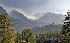
   Scenery between Hawai and Kibithoo Scenery between Hawai and Kibithoo | |
  | |
| Coordinates: 27°53′7″N 96°48′37″E / 27.88528°N 96.81028°E / 27.88528; 96.81028 | |
| Country | |
| State | Arunachal Pradesh |
| District | Anjaw |
| Government | |
| • Type | District Panchayat |
| • Body | Hawai zilla panchayat |
| Population | |
| • Total | 982 |
| Demonym | Hawaiwashi |
| Languages | |
| • Official | English|Hindi |
| Time zone | UTC+5:30 (IST) |
| Vehicle registration | AR |
Hawai is the district headquarters of Anjaw District (created in 2004) in the state of Arunachal Pradesh in north-east India.
Location
It is located at an altitude of 1296 m above sea level on the banks of the Lohit River, a tributary of the Brahmaputra River.
It is nearly 50 km south of Walong airstrip, 80 km south of India-China LAC (at Kaho), and 120 km southwest of Diphu Pass near India-China-Myanmar tri-junction.
Etymology
"Hawai" in Kaman Mishmi dialect means "Pond". The Mishmi are the main ethnic tribe in Anjaw District.
Transport
The 2,000-kilometre-long (1,200 mi) proposed Mago-Thingbu to Vijaynagar Arunachal Pradesh Frontier Highway along the McMahon Line, (will intersect with the proposed East-West Industrial Corridor Highway) and will pass through this district, alignment map of which can be seen here and here.
Demographics
As per 2011 Indian census, Hawai had a population of 982 of which 625 are males while 357 are females. Population of children with age 0-6 is 83 which is 8.45% of total population of Hawai. Hawai has an average literacy rate of 80.31%, higher than the state average of 65.38% and national average of 74.04%. Male literacy rate is around 76.79%, and female literacy rate is 86.90%. The female sex ratio is 571 against state average of 938. Moreover, child sex ratio in Hawai is around 1128 compared to the state average of 972.
Religion
Others include Sikhism, Jainism & Other religions| Religion in Hawai | ||||
|---|---|---|---|---|
| Religion | Percent | |||
| Hinduism | 87.78% | |||
| Islam | 8.45% | |||
| Christianity | 2.44% | |||
| Buddhism | 1.32% | |||
| Others | 0.01% | |||
According to the 2011 census, 87.78% of the population is Hindu, 8.45% Muslim, 2.44% Christian and 1.32% Buddhist.
Languages
Languages spoken in Hawai Town (2011)
Mismi (38.69%) Nepali (16.90%) Bengali (10.50%) Hindi (6.62%) Assamese (6.62%) Others (20.67%)According to Census 2011, Mishmi is Spoken by 381 people, Nepali at 166 people, Bengali by 103 people, both Hindi and Assamese at 65.
Media
Hawai has an All India Radio Relay station known as Akashvani Hawai. It broadcasts on FM frequencies.
Banking Facilities
The list of banks functioning in Hawai:
- State Bank of India, Hawai
See also
- North-East Frontier Agency
- List of people from Arunachal Pradesh
- Religion in Arunachal Pradesh
- Cuisine of Arunachal Pradesh
- List of institutions of higher education in Arunachal Pradesh
| State of Arunachal Pradesh | |
|---|---|
| Capital: Itanagar | |
| State symbols | |
| Topics | |
| Administration | |
| Divisions |
|
| Districts | |
| Major towns |
|
| Historical places | |
| Portal: India | |
| Minority Concentrated Districts in India | |
|---|---|
| Andaman and Nicobar Islands | |
| Arunachal Pradesh | |
| Assam | |
| Bihar | |
| Delhi | |
| Haryana | |
| Ladakh | |
| Jharkhand | |
| Karnataka | |
| Kerala | |
| Madhya Pradesh | |
| Maharashtra | |
| Manipur | |
| Meghalaya | |
| Mizoram | |
| Odisha | |
| Sikkim | |
| Uttar Pradesh | |
| Uttarakhand | |
| West Bengal | |
| Source: "List of 90 Minority Concentration Districts" (PDF). www.minorityaffairs.gov.in. Retrieved 2 September 2020. | |
| States and union territories of India | |
|---|---|
| States | |
| Union territories | |
External links
References
- ^ "Anjaw District". Archived from the original on 14 November 2006. Retrieved 27 October 2006.
- "Top officials to meet to expedite road building along China border". Dipak Kumar Dash. timesofindia.indiatimes.com. Retrieved 27 October 2014.
- "Narendra Modi government to provide funds for restoration of damaged highways". dnaindia.com. Retrieved 27 October 2014.
- "Indian Government Plans Highway Along Disputed China Border". Ankit Panda. thediplomat.com. Retrieved 27 October 2014.
- "Govt planning road along McMohan line in Arunachal Pradesh: Kiren Rijiju". Live Mint. 14 October 2014. Retrieved 26 October 2014.
- http://www.tribuneindia.com/2014/20141016/nat7.jpg
- "State map". arunachalpradesh.nic.in. Archived from the original on 6 March 2016. Retrieved 20 September 2022.
- "China warns India against paving road in Arunachal". Ajay Banerjee. tribuneindia.com. Retrieved 26 October 2014.
- "Census of India 2001: Data from the 2001 Census, including cities, villages and towns (Provisional)". Census Commission of India. Archived from the original on 16 June 2004. Retrieved 1 November 2008.
- "Population by Religious Community". Census of India. Archived from the original on 13 September 2015. Retrieved 10 May 2016.
- https://censusindia.gov.in/nada/index.php/catalog/10194
- "State Bank of India Hawai, Branch Details".
| Places adjacent to Hawai, Arunachal Pradesh | ||||||||||||||||
|---|---|---|---|---|---|---|---|---|---|---|---|---|---|---|---|---|
| ||||||||||||||||